

 |
| Mount Cleveland is in the back with a cloud over the very top. It is the tallest in the park. |
 |
| Interesting pine cones, orangey red... |
Starting elevation 5,200 feet
Gable pass 7,480 feet
Miles hiked: 12
We were up early to boil water as our water is undrinkable. We can not remember how long you should boil water in oder to make the unknown drinkable, so we go with a 15 minute rolling boil. That should kill just about anything, right? Settling in, we have a leisurely breakfast and before you know it we were late leaving to go to our Ranger lead hike. So we gathered our stuff and ran out the door.
The hike we will be going on today starts just south of the Canadian border. On our drive my job was to try to get the phones all set up to be in International space to avoid international roaming charges. Of course one of the phones was just like the directions from Sprint and the other phone was not like the directions. Figures, I just shut them both off so we don't get charged an arm, a leg, and a spleen for the phone searching for a network. Seriously, if you travel Internationally or are close to an International border, shut the phone down. BIG bucks if your phone roams over the border...worst than trying to bring fruit across the border!
Kathi needed my help watching the road as there were many road bikers weaving and sucking wind as they road up the hilly highway. These bikers would not hold a candle to the road bikers we have seen climbing the mountain roads in Colorado. There was a lot of weaving going on so they must have really been suffering! The road was also loaded with free range cows which were camping out on the road. Along with the cows camping in the road came the obvious dispersement of numerous cow pies. When driving on a highway at any speed you should try to avoid driving over fresh cow pies. It is sort of a lingering smell...
We made it to the parking lot just in time to run to the pit toilet before meeting up with the Ranger and other hikers for this hike. As we listened to the pre-hike speech we got our hiking boots all laced up and hiking poles deployed. Well almost deployed. One of my (Penny's) poles was not locking. So I left one pole in the car and spent the day thinking about how just before the trip I was standing in REI coveting a new pair of hiking poles... Boy would a new set of poles be great, now! I did not buy them as they are kinda pricy for a pair with shock absorbers that compact small enough to fit into a suitcase. My thought bubble keeps dreaming up new poles, new poles, new poles...)
The hike starts in the woods and stays in the woods for five of the six miles that you hike up. Lee Ridge is a ridge of moraine rock pile left by the pushing of two glaciers side by side depositing rock and gravel into a long ridge. Over time the ridge grew trees and other fauna. The ridge also had kettles tucked off on the sides, for those of you who are reading this and and are not familiar with kettles they are deep impressions in the ground where the glacier just created a bowl in the ground. There is no inlet, outlet or spring which allows water in or out of the kettle, it is merely a collection of water that has fallen from the sky and stays there until it evaporates or until it has successfully allowed 10 million mosquitoes to be born. These kettles create lovely mosquito breeding factories. This hike provided a good opportunity to practice my application of bug spray. I have my technique down now, and can apply while walking with hiking poles, oops I mean hiking pole. I'm really quite talented.
I spent the first three miles of the hike thinking and wondering if we could drive up to Waterton to buy a new set of poles. I wonder if the sporting goods store there would have what I was coveting or would I have to settle for a pair they had in stock. Hmmm, hiking with one pole feels weird, sort of naked. I keep thinking I should go back because I must have set my pole down somewhere. My left hand just did not have anything to do.
Since we were in the deep forest there really was nothing to look at we did a lot of group conversations. One family of four on the trip were very interesting to talk to, but were very high maintenance. Other than untimely bathroom breaks for one of the two boys, the parents needed frequent stops for a breather, clothes adjustment, weight off loading from one backpack to another family members pack, bug spray application stop, etc. And for every minute we stopped for them, they keep telling us about how great of hikers they all were. Both boys started hiking when they were very young, why they even did the Iceberg Lake trail when they were just 5 and 7. Oh the boys go off on these high adventure hiking trips with the Boy Scouts. Can you just hear the mom and dad bragging on these kids? Too bad the mom and dad did not spend more time getting in shape as they had a difficult time with the slow steady elevation gain. By 4 miles, the mom had off loaded much of her pack and was really struggling. Perhaps she was headed for heat exhaustion. She needed to stop and sit awhile. The Dad made a decision to stay with her and send the boys on with the rest of the group. Nice, now the rest of us are all responsible for them. Well since the boys hiked faster than mom and dad we actually were able to move faster once they were out of the picture. But now the responsibility of their safety falls on us. Hmmmm.
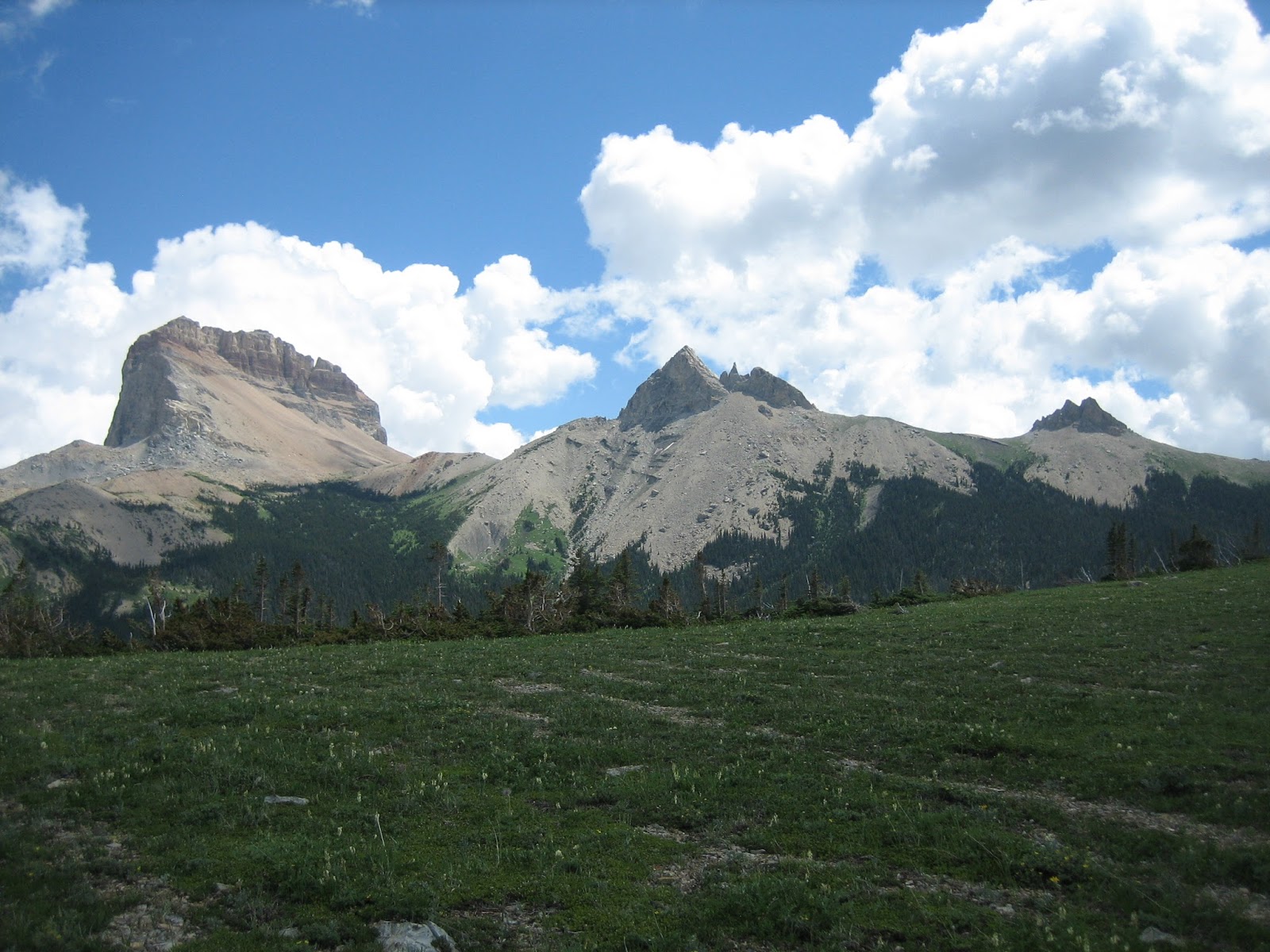 |
| Chief Mountain, Nanuki, and Pappoose mountain |
We made the high meadow for a fabioulous view of Chief mountain, listened to Ranger Sarah's speech on Chief Mountain and it's spiritual meaning to the area.
Chief Mountain is a place where particularly powerful and significant visions can be obtained through fasting and prayer (vision questing). The Blackfoot People have lived
near Chief Mountain for millennia and are aware the mountain holds great power and ancient knowledge. Use of the mountain for ritual and ceremonial purposes goes back
thousands of years. It is a sacred area.
-National Park Service
We pressed on up to the top of Gable ridge. At the top we were up to 7,480 feet above sea level and 6 miles away from the car. There is a very close view of Chief Mountain, Nanuki, and Pappoose mountain and then a long view out over the rolling prairie. Miles away you can see the clear cut path through the forest identifying the Canadian/USA border. Yes, the forest is really clear cut to make a clear divider.
There were two other gentlemen on our trip. One guy had about 10,000 dollars of cameras, assorted lenses and other assorted camera gadgets hanging on him. He also had a garmen 60c GPS. Rocking high powdered gadget! The other guy had nothing but a shoulder messenger bag which had one water bottle and a sandwich. This guy wanted to know the numbers; how far, how fast, what time, how high. How about just walk and enjoy...
Time to head back. We return down off of the high meadow and collect the four people who have decided to hike slower. They are sitting at the very beginning of the meadow waiting for us. The trip down seems like a continuation of the trip up. Waiting for two of the foursome family for one thing or another.
On the trip down, I chat with a lady that is on the hike with us. I tell her about my hiking pole dilemma. She tells me about a video she saw on-line about how to fix your pole if the tightening mechanism does not work. She said to pull the pole all the way out, twist the poles, and then put the poles back together to see if it will tighten. I tried this technique when we got back to the car and it worked! That saved us a lot of time not having to drive to Waterton and money! But I still am coveting new poles. Perhaps next year?
No comments:
Post a Comment