
Feet of elevation ascent 1972
Feet of Elevation Decent 4045
CAmped at 2448 our lowest night
11.5 miles of hiking
Very long day.
Included side trip to the Natural Bridge that is far above Lake Ethel and Lake James
I checked all of the photo's everyone put into the group photo album and found no photos of the tents stacked on top of each other. Too bad, as it was just a tight-knit grouping of tents. We packed up a wet tent again and headed out for a long hike to Ipsut Creek camp. When reserving sites for the wonderland you have to submit and be accepted to certain sites. Jen and Carrie had tried to secure a campsite at Carbon river campsite but were not able to get it. The altered plan created a long off course hike to Ipsut Creek camp for the night. Around 2.4 miles out of the way today followed by 2.4 miles backtracking tomorrow.
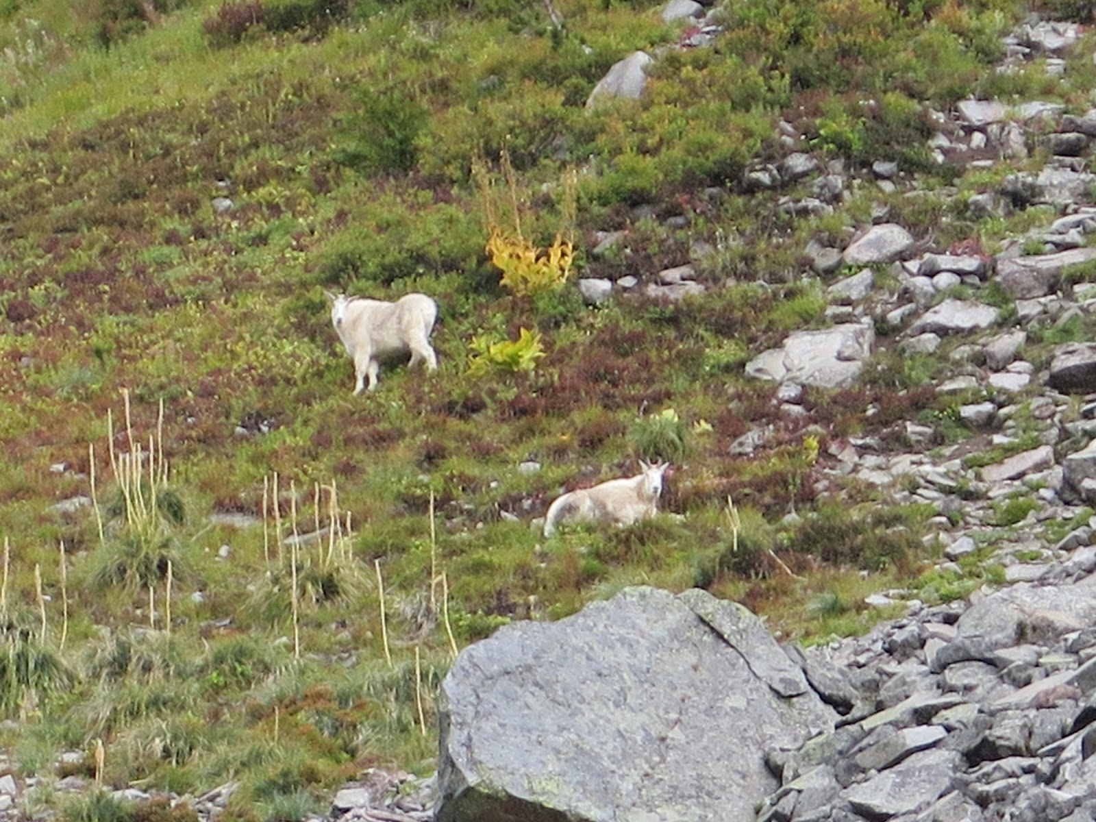
We spend a good deal of time hiking down the steep switchbacks of the side ridge of the mountain we are on. We have to hike down to cross over the river then go over the next mountain at a place called Windy Gap. As we are hiking down the switchbacks we see a section of the mountain that had burnt. With the low cloud cover is looks to be smouldering, but it is not. This makes for an eery photo. We had a first siting of some mountain goats above us on a rocky slope. At Windy Gap, we dropped our packs so we could do a fast hike side trip. We took a 1.8 mile round trip side trip to see a place called the Natural bridge. The Natural Bridge is a stone arch formed from eroded andesite lava over a small canyon. Alert!!! Some people are brave enough to hike up and over that thin little arch! None of our group even dare to think of such a thing! We had clear views of Lake Ethel and Lake James far below. One the way back we sited some more goats. One of the large goats has only one horn. This portion of our day is as close to sunshine as we get for the day.
Arriving back at our dropped pack we continue on down the trail. The clouds and heavy mist have returned and just as we walk under a place called Yellowstone Cliffs the clouds and heavy mist parted just long enough for a picture before closing up the view. The cliffs are more orange than yellow and rather pointy. Orange stone cliffs just do not have the same ring as Yellowstone... Tyee Peak is the jagged pointy peak. Easy to pick out from a distance. We shall have some glimpses of the Yellowstone cliffs later on in our trip. Right after the cliffs, we have to bundle up and hike slowly, carefully and quietly past a known beehive on the trail. It is clearly marked with survey tape and a long message provided to take caution. Anyone getting stung out this far better know if they are allergic or not as help is a long way away! Fortunately for us, it is cold and rainy, making the bees slow and lethargic. The bees will want to be home inside of their nest today. Goodness sometimes comes wrapped differently than what we would expect.
We have lunch just past the Yellowstone Cliffs. We were going to go down to Yellowstone campsite for lunch, but it is much more elevation drop and distance that we want to add to our day. So we just set up lunch along the trail. I remember having smoked salmon and skinny cow cheese smeared onto a mini bagel. I remember this being really tasty!
The trail down to the Carbon River was filled with very steep switchbacks. I read in my book about the wonderland trail that the author said: "she lost track after 20 something switchbacks". I can say that it is easy to forget to continue to count because the steepness of the trail demands your attention. Shelly in our group is really struggling with her feet and knee. She has a VERY infected big toe, blisters on heel and pinky toe also. She is a REAL TROOPER! She does not complain, and when offered help, she refuses. But the steepness of this trail is no joke. Our group does a shakedown on her pack. Heather and Aaron take about 10 pounds of gear from her pack to help her out.
After a cold wet long day, we reach the Carbon river which we must cross and make our last 2.4-mile hike down to our campsite. It is raining again and it is getting late in the day. The trail is at this point rather flat and close to the fast rushing Carbon River which comes from the active Carbon Glacier. As we are hiking it is easy to see how the river pathway has changed due to rain, flooding, and fast melting snow. At times the trail becomes very thin. At one spot, in particular, the trail is on one side a 20-foot plunge into the rushing Carbon river the opposite side is the verticle face of a solid rock wall. The trail is no more than 12 inches wide. Hmmm, go slow, three points of contact, stay in the moment. This is a be in the moment...moment. We all pass without incident. More tromping down to Ipsut.
We arrive at the group site, cold, wet, tired, hungry and late in the day. We set up wet tents as fast as possible, because as you might imagine... it is going to start raining very soon. Just when I am thinking of getting out of my cold wet clothes Jen informs Kathi and I that we are on duty for supper. I think this is just about the moment when I want to cry. I'm sure Jen and Kathi both wanted to cry too, but we all put on our happy faces and got out to make supper. Bless Jen's heart as she grabbed the water bag and went for another hike to gather some water for supper. The water source is for this campsite was around a half a mile back up the trail. How can this be? One benefit to this campsite is we have bear boxes and real pit toilets.
Ipsut Creek campsite was a casualty of the 2006 tropical storm and residual floods that took out much of the park that people visit. The National Park Service made the decision to close the whole park for 6 months so crews could start to make repairs and rebuild trails and campsites. Ipsit is still waiting to be rescued and returned to it's former self.
Tonight's meal had a lot of onions in it, so, fortunately, Jen had other soup for Kathi and I. We also busted out the large jar of Nutella and while others had appetizers of a guacamole on a toasted soft shell, Kathi and I enjoyed a toasted soft shell with Nutella! That goes a long way to making us warm up.
By the time Jen, Kathi, and I finish cleaning up supper the rest of the gang were all zipped up tight into their yet again wet tents. Kathi and I cold and talk Jen into boiling up some water so we can sleep with a hot water bottle in our sleeping bags. Score! That water bottle goes a long way to help us warm up. While I am supposed to be sleeping, I spend time listening to it rain and wondering how much rain it would take to wash out the remainder of the trail where it is only 12 inches wide...
Morning comes, our boots are still wet inside, socks still damp, bottoms of rain pants wet, raincoat damp, but my sleeping bag was warm all night. And yes, the tent was packed up soaking wet again.
 |
| Heading to Windy Gap |
 |
| Raining and hiking towards Yellowstone ridge |
 |
| Natural Bridge |
 |
| Dropped packs and headed towards the natural bridge |
 |
| Huge mossy rock |
 |
| Gathered to see the bridge |


 |
| Mountain Goats above us. |
 |
| Damage still evident from 2006 |
 |
| Goat with one horn |
 |
| IS there really a Mountain called Mount Rainier around here? |
 |
| Almost sunshine. Starting back after seeing the bridge. |
No comments:
Post a Comment