RMNP 16 Notch Top Mt. Bear Lake to Fern Lake

RMNP 16 Notch Top Mt. Bear Lake to Fern Lake

Thursday, September 27, 2018

Granite Peak Campsite to Sunrise Trailhead

Coffee at 6 am and on the Trail by 8am  We have been pretty consistent with leaving camp 2 hours after coffee.  Kathi and I get up 30 mins prior to coffee so we can get our contacts in, dressed, sleeping bags stuffed, mattress pads rolled and stuffed, backpacks prepacked.  The only thing we have remaining is rolling up the wet tent...I mean tent.

This morning it does not take long to get the food bags down from the bear pole.  They are light and few in number.  This morning for breakfast we have oatmeal with hazelnuts and coconut flakes along with Nutella for sweetener.  Tastee goodness!

Tents roll up fast as of course, they are wet, we all know that they will have to get dried out later.  During breakfast and camp tear down the clouds were moving fast and had glimpses of blue sky, quickly followed by grey rain filled clouds dripping on us.  We can see it snowed at around the 6000-foot level. Our landscape has a nice white furry cap on it.  It certainly is chilly enough!  We must have just stayed above 32 degrees overnight as we only had rain.

At this time I would like to say how thankful I am for Merino Smartwool!  Both Kathi and I wore pants and long sleeve merino as PJ's in our sleeping bags.  Our sleeping bags are rated to 15 degrees and we each have insulated backpacking air mattress, but the extra help with the merino SmartWool and hot water bottles really saved us!!  We had brought along on our trip lighter weight long sleeves to sleep in, but as our backpacking trip drew near, we were watching the weather channel predictions for our expected temps overnight.  We drove to the nearby town of Ashford and went shopping at Whittaker's.  We also picked up a little boot waterproofing.  LOL, turns out that you have to warm your boots to 120 degrees to get the product to soak in.  I did not read the fine print!  120 degrees? not on this hike!

We peak out at 6700 feet
ascent 1453
decent 938
5 miles

As we climb the switchback up to our highest point next to Skyscraper Mountain we are teased with brief views of Mount Rainier.  There is no dought that we are missing out on a spectacular view.  We stop briefly at any of the breaks in the tree's to shoot some hopeful photo's.  When we make it to the saddle at 6700 feet we drop our packs and use the opportunity for taking "I did it Photo's".  We also looked across at Skyscraper Mountain and see the hike scramble to the top right in front of us.  Perhaps a different day.  I think we are all feeling the effects of the long hard days we put in.  I don't know how Shelly is managing to still walk, but she does so without complaint.  Dr. Judy has patched her up at the beginning and end of these past several days.  To help Shelly out, we have offloaded some poundage from her pack so she can move a little easier.  Shelly, of course, does not want to accept the help, but with a few tears of thanks, she finally relents.  She is a woman of strong fortitude and is clearly used to being the provider of gifts rather and the receiver.  Sometimes receiving help is the hardest thing to accept.

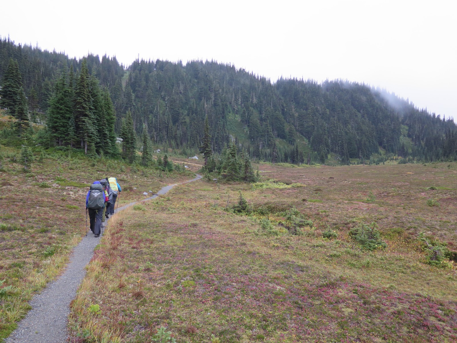
As we drop down from the saddle into our final few miles some of the clouds lift and reveal a longer view for us.  We can see back into Grand Park where we were on our first day.  Looking off in the distance where there was once smoke from the fire to the north, it is clear.  I am sure with all of the rain the fire MUST be under control...

We stop for a group photo at a trail junction.  There are several people passing through and it is easy to ask someone to take the photo for us.  Then we make our way down to the end of the trail.  We step off the trail together.  Head to our cars to drop gear, change shoes, dress warmer and meet for lunch.  Jen left today's lunch in her car so we did not have to carry it around the loop for the week.  We had planned on having lunch in the snack bar/gift shop area.  But it is after Labor Day and the snackbar/gift shop building is closed for the season.  We move or lunch of peanut butter and jelly with chips and salsa up to the outdoor picnic tables.  We share a few laughs about what will be our first purchase of new gear.  All responses have something to do with keeping dryer or warmer.  No surprise there.

43.1 miles
Uncountable opportunities for perseverance, finding happiness amongst the weariness, finding strength amongst friends, giving when you have something to give, accepting help when you need help, finding beauty and grandeur in the close and near.

Kathi and I drive back to Seattle, well actually we stay in Bellevue.  The traffic in the Seattle area is TERRIBLE!!! Yikes!!  We arrived at the hotel, checked in, took our stuff up to the room and pulled out all of the wet gear to dry.  The room looked like the clothes hamper exploded in the room.  Then we went out to the parking lot and pulled out the tent.  I'm sure the Larkspur Landing appreciated us using the available shrubs and bushes to drape our tent over to dry.  We just needed it to get dry enough to travel home.  After this, we took LONG HOT SHOWERS and drove to downtown Bellevue to eat some seafood.  Sleep comes easy tonight!

Things we carried around and did not use:

  • Camp shoes-it was too wet and muddy to use them.
  • Book to read-after reading two sentences I found out I had read the book previously.
  • Boot waterproofing-need to warm boots up to 120 degrees to work.
  • Tripod for camera-Always raining, could never set up a shot without camera getting soaked.
  • Tea to drink at night-only one day did we get to camp early enough to have tea.  
  • Sunglasses
  • Sunscreen
  • Bug repellant


First Item Kathi and I bought from REI upon returning home:

  • A New raincoat!  And no $300 is not too much to spend!


Other items that are a close second:


  • Waterproofing for boots that can be applied at any time and any temp's.
  • Additional Smartwool top and bottom
  • Looking for drybag stuff sack to put around sleeping bag stuff sack.  I don't think double dry around a sleeping bag to keep it dry is too much protection.  


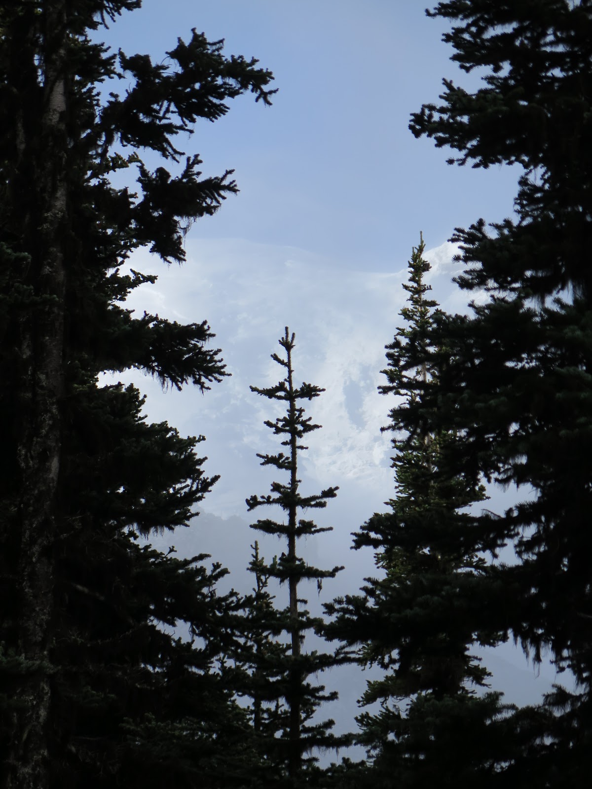
The elusive Mount Rainier

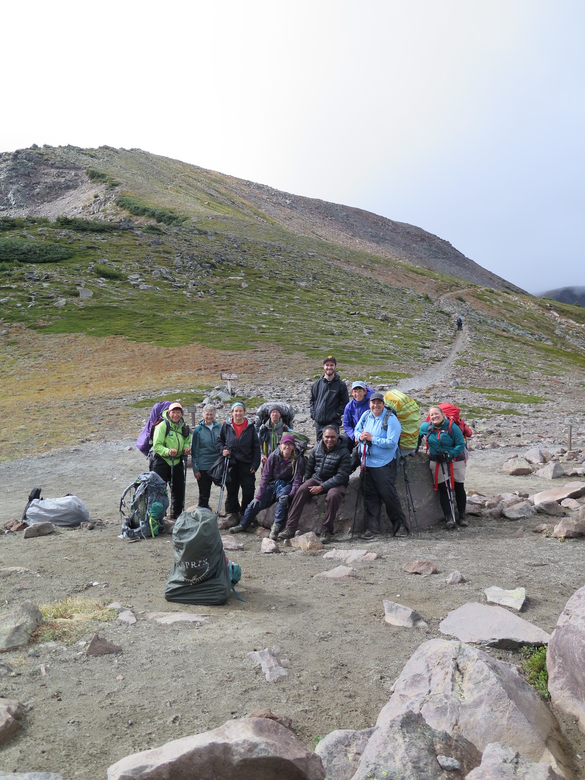
A well and fine tuned wet hiking machine!

Quick don't blink!!  It is right there!

Morning snow

clouds hanging in the valley

Better take a second look

Really it was right there a moment ago!

Last few steps


Off is the distance is Grand Park, when we hike the Burrourghs this was all smoked in.

Coming down together

From the left: Carrie (leader), Aaron, Kathi, Shelly, Jen (Leader), sitting is Dr. Judy, middle is Canadian Heather, Ramada, Me

Any last thoughts?


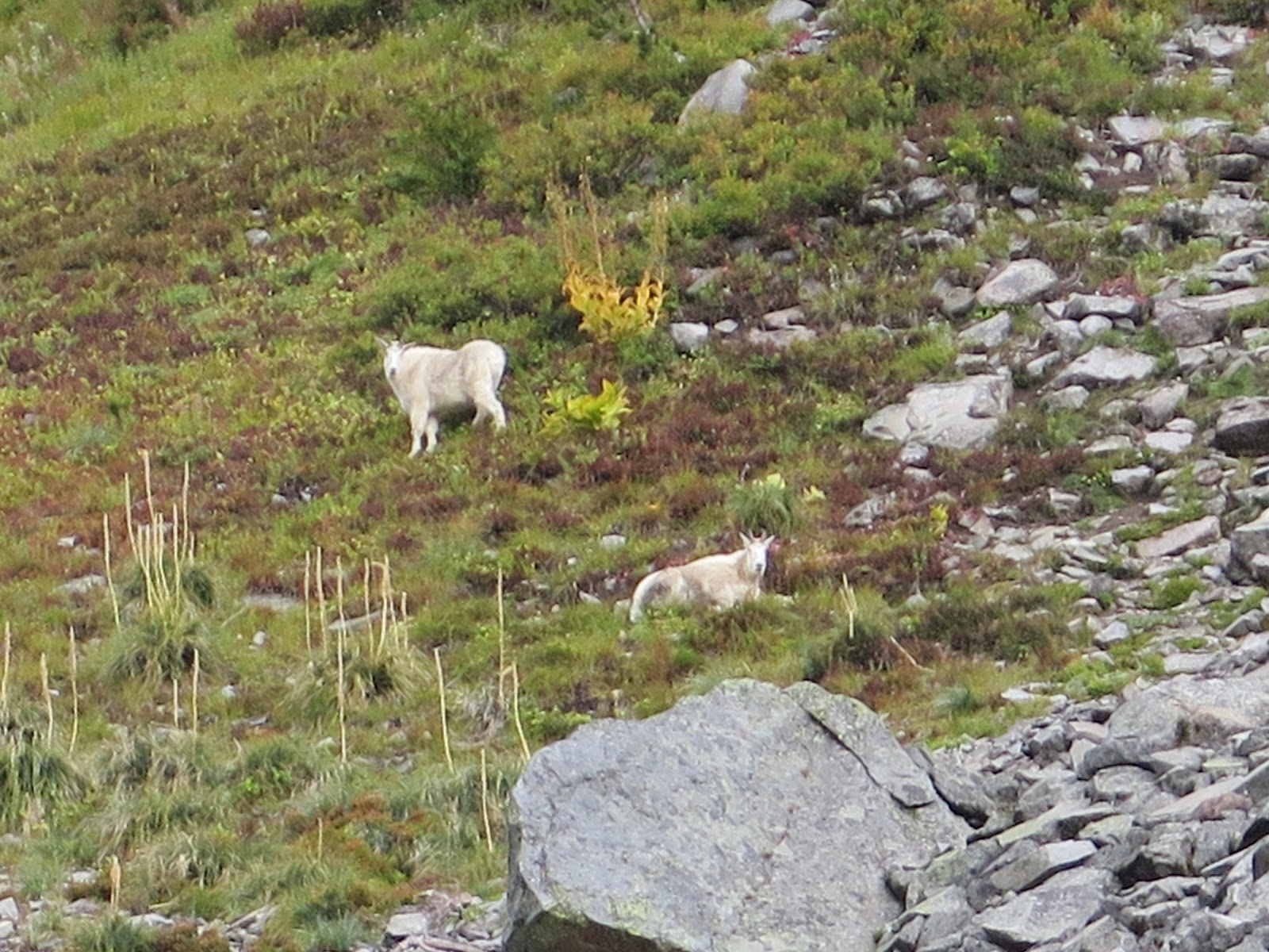
Goats are in the middle of photo up towards the top of the ridge


Wednesday, September 26, 2018

Mystic Lake Campsite to Granite Creek

PEak 5863
Ascent 1371
Decent 1007
4.4 miles
Left Camp at 10 am and arrived at 2:30  Short day!

We went to sleep last night with very heavy mist/rain starting.  During the night there was a long sustained rumble of ice falling from the nearby glacier.  One, in particular, was thoroughly discussed at breakfast.  We all commented on our thought process of how we all were laying there wondering...glacier or thunder... Morning brings heavy skies, but it is not raining yet.  We pack up in a state of wet, but not dripping.

Our hike today takes us past Winthrop Glacier and the devastation from more damage from the 2006 flood.  The photos do not really show the massiveness of the path the melted waters made down through the valley.  Some of the trail is a bit sketchy, but we have become accustomed to the sketchiness.

Today there is a waterfall called Garda Falls.  It has a fall of around 200 feet.  It must have been in the clouds.  Not one of the people with cameras has a photo of the falls.  It must be hiding like Mount Rainier.

Lunch today is pita bread with hummus.  Gross!  Kathi and I don't do hummus, so we had pita bread with jam and almond butter...Strike that-almond butter is gone.  Pita bread with jelly.  We also had to share a mini pack of Trader Joe olives with a partner.  Lucky for me Kathi does not like olives, so I had a special treat of all 12 olives to go with my pita bread and jelly.  I think we had some sort of almond season seed cracker for dessert... I still am at a loss for what it really was.  I hope supper is a bit more substantial.

We arrive at camp early and hardly know what to do!  We set up and manage to get almost completely set up before it starts to rain.  This is another three-tier group camp and it requires some math skills to figure out how we can make the best use of the space.  We also have a privy that seems really close to camp, it has a wall, but really close.  And stranger yet, within 20 feet of the bear pole.
We have a neighbor in camp.  He is taking his second trip around the Wonderland trail this summer.  His wife told him to see if he could squeeze in another trip this year.  He decided to give it a go.  He looks like he is ready to just jog around the mountain, so I think he will make fast work of the trip.

We have gotten accustomed to also starting supper as soon as possible when we get to camp.  And without much notice, we are tents up and water boiling only to find we are ready to start supper at 4 pm.  Kathi and I splurge and have two cups of tea to warm up.  Having early tea gives us a chance to get it all processed before going to bed.  For dinner, Kathi and I have some sort of potato cheese soup and some Nana bread.  I think the rest of the group is having some sort of Indian curry something.  It has onions in it so it is off the menu for us.

We stand around and chat knowing our time together will end tomorrow.  It is raining on and off throughout our evening.  It is another cold night and we all go to bed with a hot a hot water bottle.  It is very chilly tonight.

We wake to snow at the 6000-foot elevation.  What we can see of the surrounding mountains they all have a snowy hat on now.  Burrrr chilly.

Privy at Mystic Lake

We saw a lot of Rain and little of Mount Rainier

Pathway of the floods coming down from Winthrop Glacier in 2006

Looking up at the glacier, Mount Rainier is hidden in the clouds.  Rock covers the lower glacier.

Empty bear pole with the lifting pole attached

this is a nice falls, but not the one we suppose to see.

Campground at Granite 


Nice privy up at the neighbouring campsite at granite...a little more privacy rather than right next to camp


Jen looking for the slow leak in her sleeping mattress.  Has to blow it up 2 or 3 times a night.

hiking down into the pathway of Winthrop, you can see the scale of the wash out compared to our group.  This was a little sketcchy hiking down this stuff.  Sort of unstable.

Our first night of food hanging on the pole.  Ten bags each about ten pounds

Down to our last three bags, some of which is trash with food smells.

Tuesday, September 25, 2018

Ipsut Creek Campground to Mystic Lake Campground

It rained most of the night but stopped sometime around 4 am.  Boots, socks, rain gear and tent are all on the wet side, but it could be worse.  After morning pancakes with Nutella, we pack up and head out for Mystic Lake.  Ipsut is at 2400 feet above sea level and Mystic Lake is 5700 feet above sea level.  We have to go over a pass at 6000 feet and drop down to Mystic Lake at 5700, then drop further down another to the campsite at 5370 feet.

During the night as I was hugging my hot water bottle listening to it rain, I was wondering about how much water does it take to wash out the remaining precious inches of trail in the one skinny spot.  We leave camp ready to take on the 3789 feet of elevation up and the 820 feet down, 8.5 mile day.  We will just see what the day brings.

It does not take to long before we are at the location on the trail where it gets skinny.  Coming from this direction one can see a rope that has been installed on the face of the rock wall. This is to help maintain balance while crossing this skinny path.  The rope is not visible from the opposing side. The skinny passage does not appear any skinner today than it did yesterday!  Yeah!! The rope is a violation of National Park Service policy.  They do not want any rope or cable aides to help.  But I suspect that this is just another spot on the list that requires a significant fix and will just put a rope there until it makes it onto the top of the To Do list.   All of us pass through the spot carefully and press on.  We arrive at the last 100 feet of Ipsut trail before we drop down to cross the Carbon River and find the trail has disappeared underneath a rock slide from overnight.  What lies in front of us is a loose jumble of rock that tumbles directly into the Carbon River and no real way to climb above or around it.  Jen our leader crosses and tries to sight out a possible crossing course.  She goes over and comes back.  Jen returns and holds a private meeting with Carrie.  They come back and offer the group a choice.

Our choice is to either "all" rock scramble across the loose rock and possibly start a new slide or "all" turn around and hike out of the park and hitchhike back to our cars.  We each are asked to go closer to the rock slide and take a look at the crossing.  Once we all had a good look at the crossing we would have a group meeting.  Either we all go forward or we all go backward.  There would be no splitting up.

Kathi and I have a good look and think it is passable.  Billy goat Kathi reminds me we have done worse... I laugh at this, perhaps we have, and perhaps this will be the last crossing... The group reconvenes and decided to go forward.  Jen offers to take over anyone's pack who feels any bit uncomfortable with trying to scramble with a full pack.  Ramada takes her up of the offer.  Everyone else pulls their straps tighter and keeps their pack.  We each take our turn crossing the slide without incident and do not tumble any of the loose rocks down into the raging Carbon river below.  Neither do we start any new rocks tumbling from the angle of repose above us.  High fives and jubilant celebration once the entire group makes it across.  This crossing has consumed roughly an hour to cross.

We stop for lunch by the famous suspension bridge.  We have only gone around 3.5 miles and it is around 12:45pm.  We tossed out a few pieces of our tent for our daily dryout.  We had a quick lunch and photo opportunity at the bridge.  Lunch was 3 mini jerky sausage links, 3 mini red babybel pieces of cheese, and 3 crackers.   We also had a whole candy bar for each of us!  My favorite part of course was the candy bar.

During lunch, the rain started up...shocking!  We packed up the tents that had dried some but could have used more time without another rinse cycle.  As we got back to hiking the rain came down harder and harder.  Until it was just a straight downpour.  We were hiking right alongside of the carbon glacier and it would have been an extraordinary site to see.  Mist was rising from the glacier as the rain hit the cold ice and vaporized.

Before we arrived at the Dick's Creek crossing and campsite we spotted a bear down along the side of the glacier.  A few of us captured some nice photos of that event.  The bear started to run towards the trees when he/she heard our voices.  That is a good sign of what you want in a bear!

When we arrived at Dick's Creek Campground we found we would have to do some rope climbing to be able to get from the creek bed up to the trail that was six feet higher.  The trail, as you might have imagined was washed out and the park service had provided a knotted rope to aid in scaling the six feet.  So far today we have had rock climbing, narrow trail crossing and rope climbing... we ask Jen what other adventures we might expect?  She said: "sun burn?"!   What a great laugh and spirit raiser that answer was clearly not going to happen!!!

There is a little plateau here before the last 800 foot push to the top.  It is called Moraine Park.  I can imagine that just a few weeks earlier it was filled with wildflowers.  It also on clear days has a full-on view of Mount Rainier...We do not see this.  We have low clouds.

The climb to 6000 feet to get over the pass was like a never-ending pathway of switchbacks.  Back and forth, back and forth.  The last 800 feet were very steep.  We stop frequently during this stretch to maintain our breathing.  Upon making it to the pass we drop our packs and take a quick bathroom break.  We don't stop too long as we still have another .6 mile to the lake and further to the campground.  I know we were all looking for some hikers chicklets at this point.  Hiker chicklets are Advil or Alieve whichever you might prefer.  But something to take the edge off of the length of the day of hiking a big weight, for a long time, over a big distance.

We don't stay long on this break, it is cold, we are wet or at least damp from the heavy rain.  We cross over a few bridges one of them was closer to an elliptical crossing.  Two independent logs that were side by side, each having a great deal of flex to it.  One must keep a sense of humour out here.  Add an elliptical workout to the daily task.

When we arrive at Mystic Lake and see the fog is hovering over the water, the clouds playing hide and go seek with the surrounding mountains.  The Sierra Club hikers from last year enjoyed swimming in this lake when they hiked this hike.  No one from our group feels like disrobing in the low 40-degree air for even a toe bath.  We continue on down the trail to find our group campsite for the night.  It is about .4 mile beyond the lake.  One of the larger group campsites with a three wall covey around the privy and our own private creek to draw water from.

Today's hike was 9 hours and we set up camp and supper in the dark.  It, of course, has started to sprinkle.  There will be another hot water bottle tonight.

We can sleep in a bit tonight as tomorrow we do not have far to go.  Only 4.4 miles :)


A large slug that was on the trail.  Was about 5 inches long.  

Suspension Bridge

Mossy creek of water we filter to drink


Large log over Carbon River

Mystic Lake with Mountain in and out of view


Mount Rainier should be straight ahead...Do you see it?  Me either.

Kathi make short work of the rock slide

Carbon Glacier is covered with rock, this toe is most likely 70-100  feet tall!  Massive!


Shelly is three points of contact on her pass, Carrie keeps an eye on any rock slide from above, Jen helps spy a pathway.

Bear

This is what you look at when you can not see Mount Rainier...

Friday, September 21, 2018

James Creek Camp to Ipsut Creek Campground

Peak altitude 5912
Feet of elevation ascent 1972
Feet of Elevation Decent 4045
CAmped at 2448 our lowest night
11.5 miles of hiking
Very long day.

Included side trip to the Natural Bridge that is far above Lake Ethel and Lake James

I checked all of the photo's everyone put into the group photo album and found no photos of the tents stacked on top of each other.  Too bad, as it was just a tight-knit grouping of tents.  We packed up a wet tent again and headed out for a long hike to Ipsut Creek camp.  When reserving sites for the wonderland you have to submit and be accepted to certain sites.  Jen and Carrie had tried to secure a campsite at Carbon river campsite but were not able to get it.  The altered plan created a long off course hike to Ipsut Creek camp for the night.  Around 2.4 miles out of the way today followed by 2.4 miles backtracking tomorrow.

We spend a good deal of time hiking down the steep switchbacks of the side ridge of the mountain we are on.  We have to hike down to cross over the river then go over the next mountain at a place called Windy Gap.  As we are hiking down the switchbacks we see a section of the mountain that had burnt.  With the low cloud cover is looks to be smouldering, but it is not.  This makes for an eery photo.  We had a first siting of some mountain goats above us on a rocky slope.  At Windy Gap, we dropped our packs so we could do a fast hike side trip.  We took a 1.8 mile round trip side trip to see a place called the Natural bridge.  The Natural Bridge is a stone arch formed from eroded andesite lava over a small canyon.  Alert!!! Some people are brave enough to hike up and over that thin little arch!  None of our group even dare to think of such a thing!  We had clear views of Lake Ethel and Lake James far below.   One the way back we sited some more goats.  One of the large goats has only one horn.  This portion of our day is as close to sunshine as we get for the day. 

Arriving back at our dropped pack we continue on down the trail.  The clouds and heavy mist have returned and just as we walk under a place called Yellowstone Cliffs the clouds and heavy mist parted just long enough for a picture before closing up the view.  The cliffs are more orange than yellow and rather pointy.  Orange stone cliffs just do not have the same ring as Yellowstone... Tyee Peak is the jagged pointy peak.  Easy to pick out from a distance.  We shall have some glimpses of the Yellowstone cliffs later on in our trip.  Right after the cliffs, we have to bundle up and hike slowly, carefully and quietly past a known beehive on the trail.  It is clearly marked with survey tape and a long message provided to take caution.  Anyone getting stung out this far better know if they are allergic or not as help is a long way away!  Fortunately for us, it is cold and rainy, making the bees slow and lethargic.  The bees will want to be home inside of their nest today. Goodness sometimes comes wrapped differently than what we would expect.

We have lunch just past the Yellowstone Cliffs.  We were going to go down to Yellowstone campsite for lunch, but it is much more elevation drop and distance that we want to add to our day.  So we just set up lunch along the trail.  I remember having smoked salmon and skinny cow cheese smeared onto a mini bagel.  I remember this being really tasty!

The trail down to the Carbon River was filled with very steep switchbacks.  I read in my book about the wonderland trail that the author said: "she lost track after 20 something switchbacks".  I can say that it is easy to forget to continue to count because the steepness of the trail demands your attention.  Shelly in our group is really struggling with her feet and knee.  She has a VERY infected big toe, blisters on heel and pinky toe also.  She is a REAL TROOPER!  She does not complain, and when offered help, she refuses.  But the steepness of this trail is no joke.  Our group does a shakedown on her pack.  Heather and Aaron take about 10 pounds of gear from her pack to help her out.

After a cold wet long day, we reach the Carbon river which we must cross and make our last 2.4-mile hike down to our campsite.  It is raining again and it is getting late in the day.  The trail is at this point rather flat and close to the fast rushing Carbon River which comes from the active Carbon Glacier.  As we are hiking it is easy to see how the river pathway has changed due to rain, flooding, and fast melting snow.  At times the trail becomes very thin.  At one spot, in particular, the trail is on one side a 20-foot plunge into the rushing Carbon river the opposite side is the verticle face of a solid rock wall.  The trail is no more than 12 inches wide.  Hmmm, go slow, three points of contact, stay in the moment.  This is a be in the moment...moment.  We all pass without incident.  More tromping down to Ipsut.

We arrive at the group site, cold, wet, tired, hungry and late in the day.  We set up wet tents as fast as possible, because as you might imagine... it is going to start raining very soon.  Just when I am thinking of getting out of my cold wet clothes Jen informs Kathi and I that we are on duty for supper.  I think this is just about the moment when I want to cry.  I'm sure Jen and Kathi both wanted to cry too, but we all put on our happy faces and got out to make supper.  Bless Jen's heart as she grabbed the water bag and went for another hike to gather some water for supper.  The water source is for this campsite was around a half a mile back up the trail.  How can this be?  One benefit to this campsite is we have bear boxes and real pit toilets.

Ipsut Creek campsite was a casualty of the 2006 tropical storm and residual floods that took out much of the park that people visit.  The National Park Service made the decision to close the whole park for 6 months so crews could start to make repairs and rebuild trails and campsites.  Ipsit is still waiting to be rescued and returned to it's former self.

Tonight's meal had a lot of onions in it, so, fortunately, Jen had other soup for Kathi and I.  We also busted out the large jar of Nutella and while others had appetizers of a guacamole on a toasted soft shell, Kathi and I enjoyed a toasted soft shell with Nutella!  That goes a long way to making us warm up.

By the time Jen, Kathi, and I finish cleaning up supper the rest of the gang were all zipped up tight into their yet again wet tents.  Kathi and I cold and talk Jen into boiling up some water so we can sleep with a hot water bottle in our sleeping bags.  Score! That water bottle goes a long way to help us warm up. While I am supposed to be sleeping, I spend time listening to it rain and wondering how much rain it would take to wash out the remainder of the trail where it is only 12 inches wide...

Morning comes, our boots are still wet inside, socks still damp, bottoms of rain pants wet, raincoat damp, but my sleeping bag was warm all night. And yes, the tent was packed up soaking wet again.


Heading to Windy Gap

Raining and hiking towards Yellowstone ridge

Natural Bridge

Dropped packs and headed towards the natural bridge

Huge mossy rock

Gathered to see the bridge


Mountain Goats above us.

Damage still evident from 2006

Goat with one horn

IS there really a Mountain called Mount Rainier around here?


Almost sunshine.  Starting back after seeing the bridge.