
 8.24 miles
5 hours hiking
Started 10,700 feet highest 12,500 feet
2,569 feet up 2,487 feet down
Total 66.4 miles
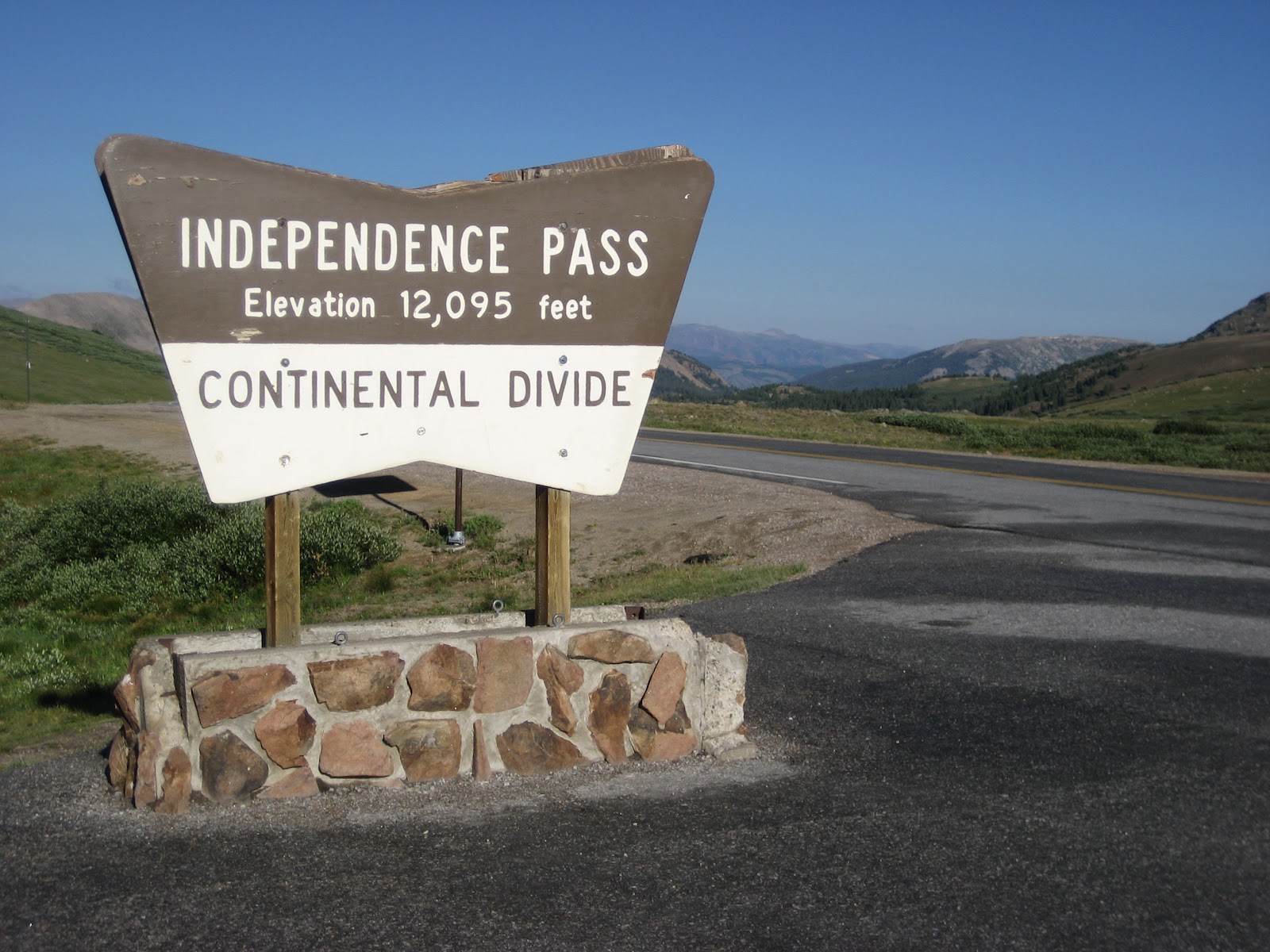
We had an interesting drive over Independence Pass today. Perhaps some of you have been on Colorado 82 over Independence Pass before? Vehicles longer than 35 feet may not use this road. I'm not sure who we should thank for that piece of mind, but we clearly should send them a note of gratitude. When the road has two lanes, neither is very wide. In fact our Traverse pretty much is yellow line to gravel edge wide. Most of that time I was sure that Kathi was driving with both passenger side tires off of the edge of the road. There are three times when the road goes down to just single car width. It is marked as "road narrows" on the road signs. The department of transportation could put up two things that would greatly improve the driving experience: 1) sign should read: one lane ahead, sharp drop off below" 2) mirrors or stop and go lights should be installed as all three of these sections go around a large mountain face wall and leave you totally blind as to what is coming around the corner. If it is another car good luck as their is not enough room to pass. We had such an encounter with a Hummer. A Hummer is rather large. Fortunately they were on the outside and we were pinned with our mirror against the cliff wall, I felt pretty good about that. We were on the inside! Ah, yes, what is driving in the mountains without a little heart stopper?
Just a few miles short of the pass is a ghost town called Independence. Right along the road are the remains of Independence which sprung up because gold was found in the area in 1879. By 1880 there were 300 people living there and up to 500 people there by 1881. The mines in the area processed $190,000 of gold in 1881 and by 1883 the gold production had fallen off to only $2,000 . (These $ amounts are in terms of gold prices during those years). Most of the towns people moved to the neighboring town of Aspen to find work and better pay after 1883.
By the winter of 1899 a series of severe snow storms left those remaining in Independence cut off from their supply routes. The few remaining miners and their families were without food, so they did what any logical pioneer / miner would do... They dismantled their houses to make 75 pairs of wooden skies and escaped in masse to Aspen. And that was the end of Independence. If you go to Independence to walk around and visit, it will cost you a $3 dollar donation. Hey gold is hard too find in them' there hills!
We drove up over the pass and down to the bottom of the climb on the other side to arrive at our next trailhead. We find we are the only car. The trail is either to the east or to the north. We pull the map and double check. We head north. Trail starts as a jeep 4 x 4 road that has been closed. I can't imagine driving anything across the rocks that were as large as kitchen sinks and bathtubs. The rocks were everywhere, but I know some people find that fun. After walking on this double track trail for three quarter of a mile we finally get onto the trail that is single track and find it choked with willows and sage. These bushes range in height from knee high to over our heads. They are dripping with water. For a while Kathi does battle with the wet bushes and finally gives in to defeat and puts on her rain gear as her pants are soaking wet. The skies are bright blue with only a wisp of a cloud so this seems like defeat.
We hike all the way back to the head wall of this valley and then start to climb up to the next hanging basin. The way the trail winds through the willows it is a mystery how we are going to get to the top of the next basin. It becomes a game of sorts trying to guess where the trail really goes. Who ever designed the trail was trying to avoid the wet bogginess close to the creek so they wound the trail every which way to avoid the bogginess, creating a corn maze of sorts.
We make it up to the second basin to find a whole new world. This has another head wall which we will be climbing. Again we comment on the layout of the trail. This time rather than staying high and walking to the pass we loose elevation that we already gained so we can walk right across a bog that we just spent one mile avoiding. The bog was very springy and sort of like walking across a trampoline. As you might imagine it was wet. This made for a nice soft walk on our feet. This bog walk took us right up to the final head wall. We made the final push up and gained the top in 17 minutes of what seems like a 30 % grade.
 |
| Trail winds every which way through these willows and sage as we head back to the mountain that is right of center |
 |
| Stream from the lake with nice smelling flowers |
 |
| Lake with fish is behind us |
 |
| Looking down at what we climbed up |
Up at the top of this final head wall is a lake which is listed as frozen much of the year. But not this year. We were able to watch the fish jump and play swimming games near the edge of the lake. We also watched a little tiny duck dive under the cold water and go fishing. That little old duck would stay under water for 30 seconds or more!
We made the final scramble up the last two tenths of a mile to the continental divide. We had half a lunch there before leaving due to a chilly wind. Back down the the trail to the first lake to watch the fish and duck again. It just would not be right unless a dark cloud came along, sure enough one did come floating over the mountain. We packed up and left. We know the drill by now.
 |
| This part of the trail is all bog that we bounded over |
 |
| Lunch table at the Continentail Divide |
Great another day of hiking without getting wet. Well, ok we did get a little wet today, but I am not going to count it as such because I did not get drenched, only sprinkled on.
We drove to Leadville in the rain. Leadville is a very old mining town and it looks like the outskirts are pretty weathered, but downtown is like driving back into the the Victorian age with houses and crazy paint choices. Stay tuned for my Leadville update.
No comments:
Post a Comment