RMNP 16 Notch Top Mt. Bear Lake to Fern Lake

RMNP 16 Notch Top Mt. Bear Lake to Fern Lake

Monday, August 21, 2017

August 2 Base Camp to Bowen Lake


 Today's hair-do award is a tie. Clearly awarded to Claudia and Marybeth. They both did a fantastic job working on their hair overnight, which they promptly covered up with a hat.  


Today we made a speedier exit from our base camp. It was a 20-minute earlier start. We headed up to Bowen Lake. A big day hike for us it's only a mile and a half to the lake. The trip is a 5-mile day and we peak out at 11,696 feet. We have an elevation gain of 1,604 feet today.  These are not big mile days for us.

The hike today was through the woods, but it had many flowers and moose tracks to look at. The trail did provide an opportunity to walk through a meadow that was filled with monks hood and delphiniums. Moments like this should always be treasured.  When we arrived at the lake there were many camping locations. We dropped our packs at the camp area closest to the water's edge. What a beautiful sight this was.  Time just seems to not matter when you are at peace with the environment.  

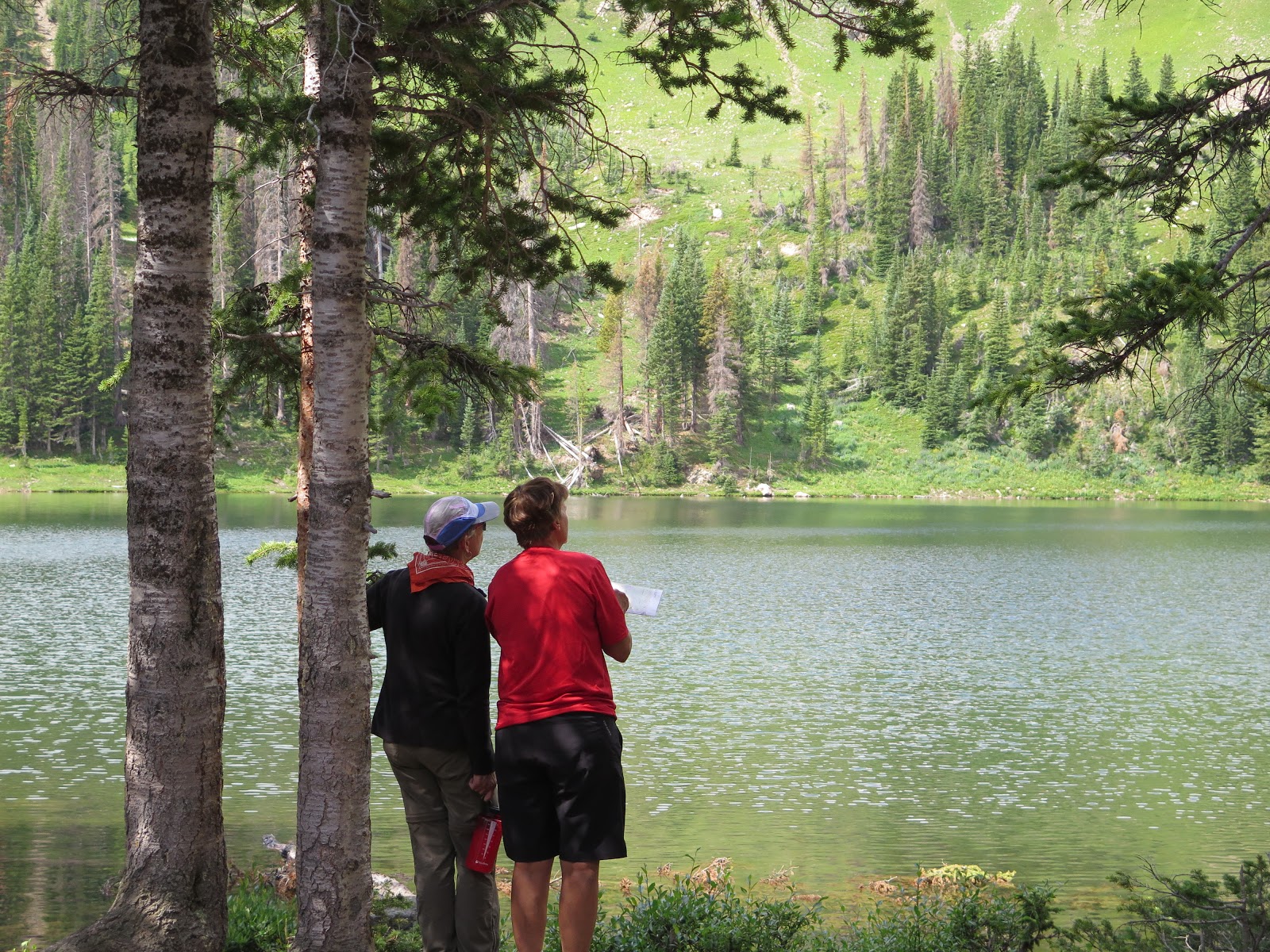
Marybeth and Pat were working on taking map bearings and talking about declination on a map. All of a sudden we heard splash! A really BIG SPLASH.  No Bec was not taking another one of her dips into the water.  Across the lake to our right, two bull moose were swimming in the lake.  Two more were entering the water, and two more looking on. Six moose, I have never seen anything like this!   We started taking pictures. The Moose heard all of our movement and did a 180 degree synchronized swim turn to head back to shore. The Moose were now pinned up against the cirque of the mountain and really had nowhere to go… Well, besides for a right back at us.
We stepped back behind some pine trees that were close by. When protecting yourself from a moose you want to find a big tree and stand on the other side of it.   Moose are not known for a high degree of agility. The large alpha moose stood on the trail looking at us and checking us out.   He cauiously came closer and closer, commanding all of our attention. He walked up to where we had our backpacks leaning and snorted, shook off like a wet dog, looked around, and headed to the main trail. Sensing a signal was being sent to the remaining five moose, we took this as a great opportunity to move further away from where we were standing. The departure of the head bull signaled his okay to his harem to proceed through the space.  The harem followed him as a group and at a distance.

What moose this close??? Not only was it quite a sight but it was all of us thinking... had we chosen the right size tree for this amount of animal moving through the woods? The moose continued to walk the lake side trail until they were on the far shoreline. They turned up into the woods and disappeared. What an amazing experience.  Never have any of us been so close to so much raw muscle.  We each collected a good amount of photos and videos to re-live the moment.  

After talking about our experience, we decided that we wanted to continue to hike up to the Continental Divide Trail.  The trail was visible up to our left.  We needed to travel much of the same space where the Moose had just traveled. We carefully walked along the lakeshore and got to the end of the trees and looked to our left.   Grazing In the meadow... the 6 large moose. The alpha male was not very happy that we were passing through the far end of THEIR meadow. We decided that walking solo on the trail past them was less threatening to them than if we all went in a large 6-person group. So, each of us, holding our breath as we traveled, quietly tip-toed across the open meadow. This is probably the part in this blog where my mother is thinking “Oh dear lord, What are you girls doing!”  Well, I guess we're living The Great Outdoor Adventure.

It didn't take us very long to get to the top of the saddle where we stood on the Continental Divide Trail. There were long views off into the distance. Some of the recognizable peaks were Longs Peak, Ida, Ypsilon, Chiquita, and Chapin. Claudia, Marybeth, Kathi, and I hiked up to the highest peak of the saddle.  At the top we enjoyed an even further view of the mountains.  The clouds were gathering, so we took some more pictures and headed back down. We gathered at the sign to take a group photo.  Now we needed to hike back down to try to get past the harem of moose. It is a good time to point out that the six of us take turns leading our group. Lucky for me, I led the group up to Blue Lake :)   Claudia volunteered for the duty.  She has the smallest physical stature of all of us, but bold in adventure.  Claudia walked forward with courage of a great leader.  We will just call her “little moose bait” or someone suggested the “appetizer” leader.

We did not see any moose on the way down from the Continental Divide and all the way back to base camp. We did see many moose tracks, but no moose, so they must have moved further into the woods. Just as we were in the home stretch Bec sneezed a LOUD sneeze.   An Achoo with such gusto that it startled the moose dickens out of all of us.  Claudia, our leader most likely needed to change her underwear after that.  

A day full of adventure and amazement.


Sunday, August 20, 2017

August 1 Blue Lake day Trip

With six women backpacking together for six days, there should be a common bond that we all look forward to everyday.  Having ice cream together is not going to happen as we did not bring along a YETI cooler.  So we decided after seeing Claudia's bedhead that our group should have a morning "Best Hair doo award."  Claudia taking first place today!  We were able to sleep in today because we have decided to hike up to Blue Lake and leave our campsite as a base camp.  This will lighten our load and allow us to move a bit freer today.  We were also concerned that there might not be many camping spots up at the lake.

Our hike to Blue Lake is a double back, of about a half of a mile, to the Blue Lake spur trail.  As we leave our base camp we have to step across one of the two water sources we are camped by.  Five of us are across the 8-foot wide creek when we hear a SPLASH.  The five of us turn quickly around to see Bec make a very quick self-arrest from the creek and scamper up the bank.  After further questioning Bec (Safety Girl), she has convinced us that the little SPLASH was really one very graceful slip into some gently rolling water.  Perhaps, one of her best landings ever.  Hmmm, we need an instant replay on this as well as a review of creek crossings.  Wet rocks are indeed wet and often slippery.  One must be mindful when stepping.  Bec said she was alright, not too wet and ready to just keep going as she would dry off as we hiked.

Along the way to the Blue Lake spur there is suppose to be another spur trail up to an abandoned mine.  We watch for signs of this trail.  It is on the 1957 TOPO map we have, but we are unable to spot the trail with our eyes.  We hike on and it takes us about an hour to hike from base camp to the lake. There was a very established camp area by the lake.  The camp area by the lake also had very smart, quick and witty local chipmunks who had a good command of the area.

Blue Lake is tucked into the base of Bowen Mountain and Mineral Point.  The lake was calm and inviting.  We sat at the lake side and worked on finding the leak in my air mattress pad.  We first dipped the valves into a pan of water and found no bubbles.  Then we dunked the pad into the lake to look for any air bubbles.  Still nothing...

While our side show was working on locating the air leak, the crafty little chipmunk was working on stealing cheese sticks from Marybeth's 2 pounds of cheese.   Two sticks of cheese at the same time! Marybeth had pulled out her camp stove for lunch and had her pots, stove and lids all spread out amongst the rocks.

Before I get to far into this story, I will take the time to explain that Marybeth is the most calm, well traveled, peaceful hiker I have ever met.  She has hiked and backpacked a huge bucket list of trails, mountains and places that have made the front of many magazines.  She is an author, physical therapist, well spoken and tells great stories.  The fact that she often leaves a "trail of forgotten things" is just part of the whole package.  The perfect absent minded professor.

Here at the lake, Pat spent time reminding me how to take bearing readings with the TOPO and compass.  While we were doing this, a group of 6 people arrived at the lake.  They were looking like they were going to be camping at the spot we were hanging out.  We packed up and left the newbies to the crafty little chipmunk thieves.  Before leaving we help Marybeth find all of her items that she had taken out of her pack.  We find her stove, pot, and lid.  We have all learned to give a good look around to make sure Marybeth has all of her items.

We have a nice hike back down to our base camp.  There was a nice display of flowers.  We do some looking for the miner trail but are once again unsuccessful.  When we get back to camp we drop our packs and four of us do some trail scouting for tomorrow's hike up towards Bowen Lake.  We are trying to decide if we should keep our base camp or of we should move up to Bowen Lake and set up a camp there.  We don't really find anything that looks like a better place to move to.  We decide no to hike all of the way to the lake.    We head back to camp and take a vote of either staying or rolling the dice.  We decided to keep our base camp and day hike up to Bowen Lake tomorrow.

Rain moved in.  It rained from 3:30- 3:40  It provided me a good opportunity to do some writing.

Kathi has volunteered to sleep on the leaky pad tonight.  Sharing the leaker will be a better way to make it through these nights.

Acclimation Hike... Are we Ready?


7/30 Berthoud Pass


Today is acclimation hike day.  We have gathered by a way of a multitude of pathways.  Claudia just finished chairing a golf outing to raise money for Sue Jergens Memorial Golf Outing.  Bec was chasing after a consultant at work, who was leaving a large path of extra work for her.  Marybeth just finished a hike around Mount Blanc in Europe and then drove 12 hours to join us in Colorado.  Pat was tending a sore foot.  I have been traveling and presenting, and finally, Kathi's Mom had just passed away.  We all needed a good walk in the fresh air with boundless beauty and peacefulness all around.

We headed up to Berthoud Pass.  Parking at the pass we were able to get out of the car at 11,307 feet and hike up to the Continental Divide.  While on our hike we had great views of the Indian Peaks, Long's Peak, Never Summer Range along with Grays and Torres as well as Beirstadt and Evans the local 14'ers.

Our goal for today was to travel at elevation to make sure we could all hike at or above 12,300 without issues.  We traveled 4.5 miles sat down and hung out at elevation awhile.  Pat's objective really was to see if anyone was going to puke...  If we had trouble with the elevation we would have felt sick.

After finishing our hike we stopped at the grocery on the way home to pick up a few items and then headed to Tabernash.  Cindy and Deb treated us to a home cooked meal of Fajitas.  We ate outside on the deck and listened to Marybeth and Cindy describe their hike to the top of Kilimanjaro.  Both with stories of a slow steady pace leading to the top of a great mountain, with excessive support from the people of the area who were their porters.

Before bed, Kathi and I sat down with Pat to re-plan our Colorado Trail hike that would be right after we completed the Bowen-Baker trail.  I say re-plan, because we planned to do the hike south to north, but with the change of plans due to delaying our vacation plans, we will now be hiking north to south on the CT.  We are trying to plan out how we can have Pat run "support" on our hike and do some hiking with us depending on how her foot feels.

7/31 Bowen-Baker or Bust

We all got on the road at 7:40 and to the trailhead by 9:00.  Deb and Cindy with their dogs Callie and Zoey dropped us off.  Cindy did a good job of making all of the packs seem as if we all had light packs.  Of course, all six of us are carrying over 40 pounds on our backs.  We stopped at the registration box/book and left a comment from our teams orange REI bandanas.  We are a "Force of Nature" and "A woman's place is in the wild".

On our way up the trail at the second creek crossing there was a place to soak feet and have a good sit and snack.  Here we learned we could best help everyone by doing a two woman lift to assist the owner with donning their backpack.  This is a much easier and healthier way of getting a 40 plus pack onto your back.  It sure beats hoisting and jimmying around by yourself to get it on.

We hiked around 4.5 miles to an elevation of 10,200 finding a great location next to a stream with a good amount of open area and most importantly relatively flat areas to put up tents.

As we set up our tents, Pat and Marybeth made a startling discovery.  Marybeth has a long history of forgetting something that seems pretty vital to the hiking adventure.  Before leaving the house this morning we thought Marybeth had passed the I "remembered everything"quiz.  It turns out that Marybeth forgot the tent stakes.  Pat and Marybeth had split up the weight of the tent by packing half of the tent stakes with the tent and the other half of the stakes with the rain fly.  So, only half of the stakes made the trip.  Pat and Marybeth fashioned up some just right rocks to use as weights to hold the tent in place.

When we finished setting up tents, Bec shared a treat of ice cream with us.  Bec used her insulated thermos and packed it full of ice cream, froze it overnight which helped keep it cool, and then packed it in to share with us. Hmmmmm, it was good!

After ice cream, we sat down for an early supper.  Kathi and I had jambalaya and hot chocolate.  Pat and Marybeth had Mac and cheese.  Bec and Claudia had a potpourri of dried foods.  We sat outside and chatted until the sun went behind the mountain.  The temps dropped pretty quickly, so we all went to our tents.

Overnight my big surprise was a leaky mattress pad.  I would just fall asleep and then wake up cold as my pad was flat and I was sleeping on the cold ground.  Bummer, this pad is only on its fourth night.  I think the valve is given me grief.  Temps overnight drop down into the low thirty's.

Having trouble with the pictures...
Will have to post without them.  Stay tuned


Wednesday, June 28, 2017

Lost Creek Trail Backpacking Final Day

It is our final day of our trip.  We are pretty certain we are 2.5 miles from the trailhead.  The water crossing on the detailed topo map is a reliable source to make this determination.

We sleep in a little bit.  We can see both hands, and if I had my contacts in, I'm fairly confident I could have seen the wrinkles in my hands. It was 6:30 when we began our morning process.  Today for breakfast we are having eggs and polenta.  Pat was debating between pancakes or oatmeal.  We helped her decide.  I wanted to see the master making cakes in the backcountry.  While making our final preparations for a sit-down breakfast, Kathi looked up to see what the clomp, clomp, clomp noise was...A BULL MOOSE! He was cruising down the path going towards the water.  ("Hey, buddy, make sure to get a good drink there as water is pretty scarce above")  He stopped in his tracks, holding his breath, and we were all holding ours... Slowly, we all came to the conclusion that we were not a danger to each other.  I sooo, wanted to walk over to the tent to retrieve my camera, but he was close enough to us that "moving" could have caused him to think we wanted to challenge him.  I waited until he was moving away before going to the tent to grab the camera.  I did get some nice butt shots, and one side view with the camera.  At his closest point, I put us about 60 feet apart.  After the moment passed, we had to pass the pop quiz from Pat.  What would you have done if he charged? The answer is, get behind the closest tree.  Moose are dangerous but have a difficult time changing direction quickly.  They have good power, so pick a sturdy tree :)  This moment was a special moment.  Besides for some dried up poo we had not seen any real wildlife other than a few chipmunks.

Now back to breakfast...Pat was in the process of making her pancakes.  She just tossed her ingredients into a ziplock, added water and started to squish it up.  Add some cinnamon for flavor, pour into medallion sized drops in the hot pan...flip with a spatula and wha`laa....backcountry cakes. We had a little medallion as a taste test.  They taste perfect!  After breakfast, we break down camp slowly taking out time.  and chatting about our trip and future trips.  Pat provides us with a lesson in triangulating our position using a compass, topo map, and the environment.  I like lessons out on the trail that are not"hard luck" lessons.  This is just the way I like to learn...no pressure!  This is a skill I would like to learn and not have to rely on a gps unit that requires batteries.  Batteries are heavy and carrying any extra weight is not a happy place.

We broke camp at 11:30 and leisurely hiked the 2.5 miles out to the trailhead. As we hiked this last few miles we crossed running water many times.  Lost Creek is very abundant down here, not so much higher up.

Our final lesson was to learn the pacing of gaining elevation when hiking with a backpack and group.  When hiking uphill slow step, breath in, straighten leg until standing bone on bone,  before taking the next step, breath out.  Walking at this pace will lessen muscle fatigue especially with a 40 pack.  Pat had led us through the whole hike, and at no time did I feel out of breath.  Even with a heavy pack!  Love it!

At the car, we changed shoes, put all of the packs into Pat's car and began the 15-mile spaghetti, washer board, dirt road out.  As you might remember from our drive in the road is mostly 1 car wide with occasional bump out for 2 cars to pass as long as one is standing still.  Imagine our surprise when we met a school bus coming up the road...followed by 5 cars and a Fed Ex truck. We tucked into the side wall bump out and held our breath as the school bus squeezed by.   Somethings you just can't make up!

We drove back to Pat and Wendy's Denver house.  There we opened everything up in the garage to dry out.  I think the temps were around 90 degrees.  We then went in the house and had a tour of their beautiful home.  Everything seemed so clean and white when you are five days removed from a shower you try not to touch or bump into anything!  We enjoyed a welcomed shower.  The trail grime and sweat washed away but the memories of the trip forever imprinted in our minds.

Cleaned and refreshed we were ready to join Wendy for a dinner at Famous Dave's.  Over some tasty barbecue and beers, we rehashed the trip.  Moose, lifeguard Pat, midnight hikers passing by, FBC's, the names of our Packs, and setting our sights on new adventure possibilities.
25 miles in


backcountry shower...


Outdoor restroom...behind a rock

After poking around in this, we think it was horse poo

The moose was...That way...


Moose

Fold it up.

One last long look.

Tuesday, June 27, 2017

Lost Creek is Right! Day 3

Ohh, Baby!  We are getting good!  Today we are up and at the breakfast thing with almost complete efficiency!  We only had to get up once! Of course, Pat is a champ at this and did not have to climb out of her chair once.  We are but weee grasshoppers at this backpack experience thing.  Pat, seems to think we are good candidates for mastering the organization needed for a one-sit meal.  We will continue to hone our skills.

We break camp at 7:42 and begin a climb that seems to go on and on.  We are hiking up to a pass called MacCurdy Park.  It is around 12,000 foot in elevation.  We do not have an altimeter, but we think we are around 10,400 or maybe 10,600 depending on where on the map we really are?  We climb slow and steady taking breaks to get our packs off and for Pat to get a drink of water.  Kathi and I have our camelback water reservoirs hooked up so we can sip away while hiking.  Pat prefers to hike for a distance or time and then drop her pack to take out her Nalgene water bottle and guzzle down some water.  No worries either is fine.  This gives us a good break from the pack and gives us a chance to do some snacking.  We do not ever really stop and have lunch.  We just sort of grazed our way through the day.  Dried fruit, a little jerky, some cheese, nuts, and Luna bars.  Each stop, I manage to find some sort of great item to snack on.

We arrive a spot in the trail that has some little pool of water.  The trail comes down to the pool, but it is difficult to see where the trail continues.  There are several little offshoot trails that come and go from the water pool.  Pat needs to soak her feet, so we have another snack and while we are doing some map reading we watch two people come down the trail from the direction we wish to go.  Lucky for us, all we had to do was watch where they came down through the rocks.  Pat had watched a YouTube from some guy who posted his trip around this trail.  He had mentioned that the trail was a bit tricky through this session.  I see why!

We finally arrived at the pass.  Most of this up hike was in the trees with occasional vistas of lumpy rock formations. There is a junction trail at this point it is around noon, so we stop for some photo's, a foot rest and some water.  We are looking at the map.  It looks like we are going to loose some elevation and then have to gain it back again.  We feel pretty good and are ready to get moving.

Hiking downhill we make good time to the bottom and cross McCurdy Creek.  The creek is pretty low, as in just inches of water.  Since we have not seen water for awhile, we ask Pat if she wants to soak her feet.  We are headed to a place called Lake Park.  Pat is going to skip this foot soak and do a foot soak at the Lake. We continue hiking.  Since we are at the bottom of the valley, we need to hike up and over the next pass.  This one seems a bit steeper and we need several spots along the way to grab a drink.  As I mentioned we are on our way to Lake Park.

Up and over the pass and down down down to the Lake... Except, we can't find the lake or water.  We drop our packs and divide up to scout for water.  We establish what directions each of us will go to search, and to not get lost...Roger that, Do not get lost!  I head back the way we came to look closer at the last campsite we walked by.  Usually, if there is a fire ring, there is water of some sort close by.  I arrived at the fire ring and started walking towards the sound of a frog.  Thinking frogs and water go together.  I found a bog.  Much further out into the bog I sighted a pond.  I could not find any water running to or from the pond.  Hmm, Lake Park is the wrong name for this place.  More like Puddle Park.  I return to make my report.  Neither Kathi or Pat found water on their recon trip.  It was pretty clear that we could not stay at Lake Park.   But we did need water.  I was down to my last 8 oz and so were both Pat and Kathi.  Pat needed to soak her feet.

So doing what all great leaders do, Pat put on her bog walking shoes (camp shoes), took the dromedary (water bag) and a cup and then set off to gather some of the bog water.  I wished I would have taken a picture of this.  Pat had to wade out into the pond to get to some sort of clear water and scoop it into the dromedary.  She said she had one step that was a bit of a surprise, but she managed to control the lake walk and did not fall in.  She said she was in up above her knees.  Thank you, Pat, for retrieving some water.  We used the water filter to make the water drinkable and filled up everyone's water reservoirs.  Hmm, the water although clear still tasted kind of boggy.  This is when you either believe in the magic of a water filter or not...  Was the pond water really drinkable?  We always carry a little crystal light lemonade packet to help improve the taste.  This was a good resource to have.  I'm thinking that believing in the power of a good water filter is a good belief to have.  We are going with it.

As we hiked out of the Lake Park area, we passed a downed and decaying Lake Park (Puddle Park) sign saying we were at 10,880 feet.  We had good look at the map and need to hike up to Hankins Pass and then down to find a good location for camping.  As we are hiking up the side of the mountain we have some good vistas of some white capped mountains.  This always is a welcomed site.

Hiking out of Lake Park was very steep.  I feel very happy to have some lemonade bog water.  We arrive at the Hankins Pass.  It is pretty clear there will be more hiking today.  There is not water at the pass.  Looking at the map we all agree that the first place with good water is our home for the night. It is getting late in the day.  Fortunately, we are all down hill from this spot.  After about a mile we find a fire ring /campsite.  The water is just barely moving.  We press on.  We have already had our fill of "slow water".  We pass a couple of young guys hiking without shirts under their heavy backpacks.  (This type of no shirt fashion is only done by young strapping male youth in the prime of their lack of brain cells. Carrying a large pack while moving means there will be friction.  Friction equals a possible blister.  Blisters while hiking is bad.)  One of the guys says there is a great site a mile or so down.  The guys behind them have the map, so if we want to check we should stop someone else. They were looking for water.  We tried to tell them there was little water ahead.  They were young. They were headed to Lake Park!  They will be very disappointed to find that Lake Park is really Puddle Park. Hope they has some bog shoes!

We continue to hike downhill looking for a good source of water and flat ground to pitch camp. Around 5:30 pm we finally came to a water crossing.  This was a good water source, and with some good recon work, we were able to spot a place to put our tents amongst some downed trees.  This was paradise!  Today was a hard long day of uphill elevation gain, lack of water, and downhill loss.  Hiked from 7:42 till 5:30.  Pat declared that today was her personal best for hiking on this trail.  As the sun set down over the hills to the west, we put up our tents, sat down to prepare our dinners.  A great day,  great meal, well-earned miles, easy conversation, good friends...life is good.  Oh, and fresh water to replace boggy water...life is even better.  We will sleep well tonight.

I am guessing we hiked around 10 miles today. I need my Gps unit for things like this.

Setting up camp

Whoa that was a big hike


Trying to id the mountain way in the distance?


Team Picture!

Wondering if we are headed to the top of this pass?