
 |
| Looking across Maroon Lake at the Maroon Bells Mountains |
 |
| Going to have to cross this snow bridge |
 |
| Yikes, cold, fast, deep, slippery |
 |
| Last few vertical feet are gnarly |
 |
| Smile |
 |
| Pretty |
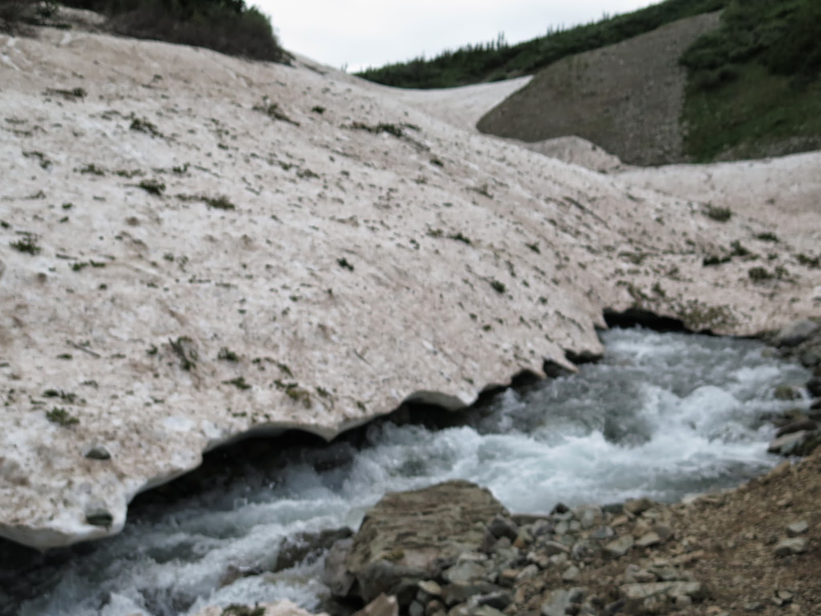 |
| On the return trip water is higher and faster. If you look at the snow bridge, Kathi went across just above the two pieces of evergreen on the right side of this picture. I went across above the four pieces of evergreen . We're guessing the snow was about a foot thick... |
 |
| It is a bit deep and fast... |

 |
| kinda steep here where we have to improve and make good choices as the trail is MIA |
 |
| This is the snowfield I head face first into! |
 |
| Refreshing |
Let's see what you think when you have finished.
We started hiking at 8:13 am. This was about an hour later than what we wanted to start, but I shall not take up any time writing all of the reasons we are slow today. Tomorrow we will get up earlier to make up for lost time. Maroon Lake is a glacier carved lake with a stunning view. Today the water was a already rippling from the wind by the time we arrived. Still a magnificent view. We took several pictures and started on our way. The trail soon turns from flat lake shore to one which says let's get to business and gain some altitude. No matter how much training you have done to prepare for hiking in the mountains, it is never enough to adequately step forward with the same abilities as you did at 780 feet above sea level. The pull of gravity against your body and muscles is like running as hard as you can but some jokester is holding the back of your shirt to prevent you from going forward. The lack of oxygen available in the air is also quite strange to your lungs. You're huffing and puffing away and your heart is ready to bust out of your chest. All of this will slowly change with the miles and time you take to acclimate to the altitude and grade of hiking in the mountains. If it were easy, everyone would be walking around in these woods.
The trail takes you past a second glacier created lake called Crater lake. It is higher in elevation, but nestled down into the valley. The wind had not yet gotten to blowing on the lake, so we had some more pictures to take. We pressed on. As we were hiking both Kathi and I are silently wondering what we will find at the first major water fording. We have been up this trail twice. One of those times we were turned back by the high water rushing through the creek. It is a 3.7 miles to the ford allowing time to wonder what are we going to be able to do. 3.7 miles is a long time to be wondering, of course we were somewhat distracted by the fact we were gaining some pretty good altitude...
Coming around the last little bend we see the creek rushing full, there is a very thin snow bridge close by, followed by a medium snow bridge, closely followed by a really sturdy snow bridge further up the valley. We set plans on hiking a very sketchy slope to get to the third snow bridge. After we were about 20 feet into this sketchy climb it becomes very apparent to me that what we are doing is in fact very dangerous and quiet frankly, stupid. Great now we have to get turned around and try to safely retrace our sketchy steps in a very loose sand and scree slope back to a safer landing spot and reassess the situation. I would have liked to show you a picture of this stupid idea, but I really scared myself and had no extra hands or extra time to pop out the camera. Ok, well let that be a lesson to hiking safely!
We choose to take the medium snowbridge as a possibly safer pathway across the raging creek. Tough decision who should go first... Since I'm heavier I go first, if the snow bridge holds, it should support Kathi right, or perhaps I weaken it and it doesn't hold Kathi.
It held both of us. Now we can wonder if the snow bridge will still be safe to travel across when we return later in the day. Ya know I have to spend my time thinking and pondering about something, right? Snow bridges melt on the top from the sun and from the bottom when the rushing creek water splashes on it.
As we head up and over the trail we encounter a huge snowfield and then have to begin to look and try to figure out where the trail picks up. The hill side we are looking at is filled with tall willows which all grow really tight together. They are impossible to just go bush whacking through. While we are looking for the trail some of the willows are moving and attracts my eye. Either a bear or hiker, lucky us it is a hiker coming towards us. So we just stand and wait for him to walk out onto the snow field so we can pick up the trail. When he breaks out onto the snow field we ask him how the conditions are and he says muddy, slippery, wet, and did he mention muddy? The trail was do'able but muddy. We press on.
An accurate description of the trail would be muddy, slippery, wet and muddy. I guess he got it right. We do our best to hike through the mess and keep the mud relatively under control. Of course with all of the mud it is a slower pace.
The next stop we have is the second major creek ford. We spend about a half an hour looking up and down the creek for a way we can get across and keep our hiking boots on. Nothing... So we are faced with either turning around or putting on our water shoes and stepping in. Ok, if you need a wake up call you just step into knee deep rushing water that is the temp of freshly melted snow and ice. Using our hiking poles to maintain balance against the rushing water we make it across. Ok, now also remember the water is only going to get faster and deeper by the time we get back on our return trip. This is going to be exciting!
We spend about 45 minutes at the river crossing. Getting to the other side we have to dry off and get back into hiking boots, then stow away our water shoes. We have 2.1 miles to get to the pass and we have to gain another 1,200 feet. As we are hiking along, the clouds are getting all busy making it look like it might rain. Well I hope it doesn't because that would be really disappointing! We have to head up over a ridge line before we can get a good view of Maroon Pass.
When we do make it above the ridge line we can see a whole group of people standing on the pass. We are hiking up and they are hiking down. We can sees they are working their way slowly across some snow fields that are across the trail. We are too close to turn back now. At some point we meet up with some of the downward heading people. They describe the pass as gnarly. The last 30 vertical feet of the trail was all melting snow mixed with small gravel and throw in some mud, then top it off with a very steep pitch to the top of the pass.
Having made it to the top of the pass, it was in fact gnarly which is a step above sketchy. Well we made it and welcomed a few pictures at the top with a speedy half of a sandwich because the rain clouds were gathering.
Did anyone ever mention going down gnarly patches are worst than going up? It's true. We somehow make all of the right decisions and steps. I think some of those steps were on total faith, because that was some very loose footing up at the top. We get all of the way down to a nice reasonable pitch before we turn to look at what we just accomplished. Wow, and as we turn to go back down the trail my right foot slips on the muddy trail and I pitch forward and to the left faster than the speed of sound, face first into a snowfield. I manage to use my hands to catch myself in perfect push up form, nose three inches from the snow. Then I make all sorts of sounds as I force myself into the upper position of a push with with the 18 pound pack on my back. Kathi turns to look at the noise I must have made as I was saving myself from the snow. She has a good laugh at me while asking what happened. Well, I slipped and pitched forward at the speed of sound saving myself from a face wash. She thought this was pretty funny and wished she had seen it...
We get back on the trail and within three minutes I am flying face first into the mud again!!! Holy cow this stuff is like grease lightening. This time my slip pitches me into the mud and I feel a muscle in my butt pull. Ouch! Ok a muscle pull is not fun, but ranks way higher on the desirable list than a broken bone. I down some Aleve and suck it up? We head back down at a slower pace towards our foot bath opportunity.
Since we know where we are going to cross and how we are going to cross the water, we just get to business and get prepared for higher, faster water at the crossing. All goes well, we dry off, and carry on down toward the snow bridge wondering what we will find there.
When we get to the snow bridge crossing we weigh the possibilities of who should go first and who should go second. Kathi decides she will go first this time. In my mind she should be further away from the edge of the snow bridge, but makes it to dry land without any issues. Well, looks good to me, but I take a path a tad further away from the edge, no reason to tempt fate here. I also make it. The snow bridges were still quite sturdy and held up for our return passage. Once across we took the opportunity to chuck a few large rocks at the melting snow bridges just to see what we could knock off of them. The hike out is long, but we make it out without any further wipeouts.
Alas, we push on for the trailhead. It has been a long day. The trip back seems long, due to all of the rocks in the path. Breaking out onto the last smooth trail past Maroon lake we run into a lady who lives in Colorado. She is giving her friends from Denver, a tour of Colorado mountains. She is originally from Albert Lee, Minnesota so we hit it off right away throwing down some good ole Minnesota accents. Ya hey, don't ya know dhere. So we do a bit of chatting and she shows us some great pictures she has on her smart phone of Maroon Lake in the different seasons. She lives in Gypsum, CO and had driven her friends up to Steamboat for lunch the day before, and today's tour was a trip over to the Maroon Bells for a lovely dinner time stroll. Meeting people like this is always fun and interesting for us. A great end to a long, but successful day.
Long day 9 hrs 52 mins
14.2 miles
Total 32.33 miles
No comments:
Post a Comment