RMNP 16 Notch Top Mt. Bear Lake to Fern Lake

RMNP 16 Notch Top Mt. Bear Lake to Fern Lake

Thursday, July 31, 2014

Hermans Gulch

This is the Continental Divide trail, for
when you get the hankering to hike the
USA vertically.

It's the last day, I just have to have my fix of columbine.

Kathi makes seat reservations on the smart phone,  way out here!
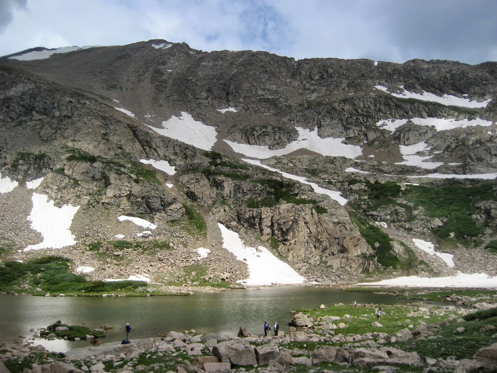
Hermans lake

Walking the Continental Divide trail

Stopped for lunch by the creek

Laurelwood Condo in Snowmass

Condo in Breckenridge, we stayed in the very top.
Should count as extra elevation  for each day!

Ok, this is the last columbine for this vacation

Alpine sunflowers, Hermans Lake in distance

Anyone know the name of this?

Add caption

The trail ends here, No really it did just end right there!

Nice Balance

My little note book

How I keep track of the days events
so I can write it down later.


Today is our last day of hiking, but first we have to make sure we have all of our belongings from our home for the last week. Since we are on the third floor with no elevator, we try to take as few of trips to the car as we can.  One would think that after hiking up and down the mountains, we wouldn't mind going up and down stairs, but when carrying a 40+ pound suitcase an elevator would be nice.  We are on the road in good time and off on our last adventure.  The trail to Herman's Gulch is well marked and right off of the interstate.  In fact for the first mile of the hike the sound of the interstate is all you can hear.  This hike is one of the 100 flowers hikes in this area.  I'm pretty sure I have never seen as much columbine as today.  This is the second hike we have taken this week which has the distinction of a "100 wild flower" label, the first being Mohawk lake.

As we walk uphill we see many shades of paint brush, columbine, delphinium, germanium, wild rose, and a few others I have no idea of the name.  We stop and shoot way too many pictures.  There are a few boggy parts in the trail, but mostly the first part of the trail is a snarl of tree roots.  Once we break out into the open meadow the trail improves greatly.

At some point along the way we remember to stop and use the smart phone to make boarding reservations for tomorrow morning's flight home.  We want to check in as close to 24 hours in advance in order to get the best place in line for bordering position on our flight.  Imagine if you can that we are miles from I-70 in the middle of basically nothing and we are on the internet making seating reservations.  

As we make the final approach to the lake we see two climbers on the head wall snowfield for Pentingell Peak.  They are up behind the lake so they are easy to see. They appear to be working up the side of the snow field and they perhaps are making some switchbacks into the snow.  They have a long way to go with some very questionable skies. We walk past the lake and to the end of the trail before turning around.  When we get back to the lake it is pretty busy now with people all out enjoying the day.

When we get back to the trail junction where we checked in for our flight, we head up the Continental Divide trail to reach a very visible saddle.  Here we sit down, have some lunch, and watch the clouds look worse and worse.  Ok, at some point today we have to face the fact that another vacation is coming to an end so we get moving for the car. We start down and when we get to the main trail we start running into many hikers all about in their 60's.  Seems like there is an organized hike today.  Well of course it is an organized hike, Colorado has so many different hiking clubs and they post who is going to be hiking where.  The hiking clubs usually hike on Fridays.  
As we are hiking down the trail we pass two people sitting on a log.  I ask Kathi it the guy was Scrub Man 
(the guy we met on top of Mount Cameron on our 4, 14'er day)
? Kathi said she wasn't looking who we walked past, ok, well it looked like Scrub's man to me.  We keep moving downhill until we find a nice spot by the waterfall to have the rest of our lunch.  Scrub man and his wife now are walking past us, so we blurt out and ask if he was on top of Democrat, Lincoln, Bross with us.  Yes, that was him.  We chat a bit.  He said he was sore and a hurting man after that big day.  We told home that we did Quandary, Grays and Torrey's also.  He said he had wanted to do Grays and Torrey's but didn't have a 4 WD vehicle to get up to the trailhead on that rough road.  We said he could have hitch hiked up... His wife said he was not good looking enough to catch a ride.  Laugh out loud.

We finish the day at 8.8 miles

Driving back to Denver, we pass 8.5 miles of west bound, backed up, three lane traffic waiting for their turn to go through the road construction at Idaho Springs.  Boy, don't we remember sitting in that traffic jam way back on July 4!

So another wonderful vacation
Hiked over 150 miles
Summited 7 fourteeners in 7/2014
That makes a total of 10 fourteeners out of 53 total.
No blisters, one pulled butt muscle, one broken toe
Next year will have to be something big as Kathi is turning 50... Wonder what we will decide to do?
Thanks for joining our little adventure.
Now it is your turn to take a Step in the Right Direction


Feel free to send any comments.

Wednesday, July 30, 2014

Gray's and Torrey's

Sun rise

We are going to go up both of those, Ready?

Walking with the Freedom Hikers

Blue skies

These Freedom Hikers like our pace and stayed with us.

Can you see the people up on the switchbacks?

A graph of the steepness of the trail

Kathi likes her 4 by 4 LO get 'em through the rough spots Truck!

The long trail

Alarm went off this morning at 3:45am. We want to get an early start today and beat the Freedom Hiker's three vans up the road to Grays and Torrey's Peak.  Those vans will not be fun to try and pass if we met them on the road to Grays/ Torrey's! 


On our way to the trailhead we have to drive through the Eisenhower tunnel which goes through the Loveland pass, and as an added bonus of well used land, there is a ski hill on  the mountain above the tunnel.  The tunnel itself is about 1.6 miles long.  One end of the tunnel you are at 11,013 feet above sea level and the far end is at 11,158 feet.  The tunnel traverses the Continental Divide.  The first tunnel was started in March 1968 and was completed in March 1973.  The second tunnel began August 1975 and completed by December 1979.  I guess they had a better idea what they wanted to do by the second tunnel.

After 18 miles on I-70 we got off right onto 4 WD road we needed to take.  Directions are to take exit 218 and proceed for 3 miles on 4 WD gravel road. The road is sometimes two cars wide, sometimes three, mostly just one car wide.  Very rocky, lots of pot holes, and boulders sticking out of the road. The fact that the road is at times wider than one car provides more options as to how one car might try to avoid the most amount of  disruption.  There is little or no concern about staying on "your side" of the road as any person driving on this road is trying their best to navigate through the least of the hazards. We drop the truck into 4 by 4 HI, that is until we see in the early dawn light, major truck eating gully ruts three feet deep all stacked up in a row just waiting to swallow us up.  We stop and drop into 4 by 4 LO.  After some major moments of wonderment, we make it through these monsters.  After those monster ruts the rest of the road seemed rather tame, but I can tell you tame it was not. This is a road you do not drive your personal vehicle up...rent one!  It took us an hour to go from the condo to trailhead.  We did get there just before the vans, as they drove up behind us.  One of the vans got hung up in the monstrous ruts, had to back down the road and take a run for it.  The ladies inside were hanging on for dear life.  Not sure I would want to take a running start at those ruts!

Everyone managed to arrive at the trailhead with a monster rut story.  At the trailhead we found many trucks and SUV's with people who had arrived late the day before and camped out.  The trails were going to be full again today.  The Freedom Hikers are all happy to see the familiar Wisconsin girls and are sharing their successes of the last few days .  Kathi and I notice their numbers have dropped off significantly.  The hikers today are the last ones standing.  Well almost, one lady made it about three quarters of a mile up the trail and then lost control of her bowel.  She just turned right on step and headed back to the trailhead.  She thought she might give it a go at hiking today, but was on the receiving end of the give it a go...

We hit the trail by 6 am and fall in line with the Freedom Hikers, chatting away about their different climbs they have taken this week. After about the first mile Kathi and I realize we should leave this group and move on at our pace as the lady hikers are rather fatigued and are moving kinda irregular in their pace.  I don't want irregular, I want regular pacing, listen to your hear rate as a pace to your hiking.  Even though their numbers have dwindled these ladies do not know the first thing about a steady hiking pace.  Kathi and I make a break away.

As we move up through the valley we can see two hikers off on the side ridge hiking up a much more difficult accent to Torrey's.  Yikes it looks daunting! Just about this time we are passed by a gentleman who must be in his late 70's.  That's right he was 70+ and passed Kathi and I and I don't think he was breathing all that hard.  These moments are humbling.  This gentleman stopped long enough with us to comment on the two hikers taking the difficult route and then dusted us up the trail. It is nice to be humbled by this ageless hiker.  

The trail switchbacks, back and forth up Grays.  You can see all sorts of people ahead of us up on the various switchbacks.  We make it to the top of Grays in 3 hours and 10 mins.  Standing at 14,270' we shoot a few photos, but we are socked in the clouds and about all that is visible is the summit. The summit was very cold.  We put on a few jackets and headed down the side of Grays .  It took a half an hour to hike down to the saddle and a half hour to hike up the side of Torrey's. 

By the time we reached Torrey's Peak (14,267) it was free of cloud cover so we we're able to shoot a few pictures of the views, along with the standard picture of what mountain we are standing on and the elevation.  In all, this is our seventh fourteener of the week, and tenth over all...yeah!  This was a great accomplishment!  We sit down for lunch, but find it is getting breezy and chilly up there so we pack up and head down.  Just as we are exiting the summit of the mountain we see the summit register, and try to sign our name.  The packet was filled with names, really filled like every space of white was filled.  Wow this trail is a busy place. The register is only for July of this year!

We head on down to the saddle and then must walk over a lingering snow field to exit the saddle.  The snow seems to have a good track on it so we did not take out the snow stabilizers we had packed along.  I punched some good heel tracks into the snow for the lady Freedom Hikers behind us.

We did run into two fellas sitting along the trail on the way out.  One had on a bright orange jacket, so Kathi asked them if they were the climbers who did the side ridge trail.  They were in fact the guys.  They said it was a difficult trail and told us about some of the sketchiness of it.  The last little bit to the summit they had to sit on the ridge as if riding a horse and skitch themselves the last fifteen feet.  Either that or walk a two inch ridge line for fifteen feet.  Let's just say it is not my kind of hike...ever!

After such a wonderful hike it was good to be finished.  It took us 7 hours and 50 mins for the whole thing.  A small group of Freedom Hikers finished shortly before us and were waiting for their three vans to arrive to pick up the group.  Kathi and I were not going to head down that road until those vans arrived.  We can't imagine what it would be like to meet those vans in the section with the thee foot deep ruts.  So while we waited for the vans, we sat around and chatted with the five hikers we spent the most time with today.  The vans finally drive in, so Kathi and I say a goodbye to our friends and hit the road.  I do mean that because when we got down to the major gully ruts the path we drove bottomed out the truck, twice.  I did not see any muffler laying there so we just kept moving on down the hill.

8.8 miles
7 hours 50 mins
Total 142.35
It is very cloudy on Grays, we can only see the summit

Grays clears and now Torrey is in the cloud

This is our seventh fourteener on this trip, but tenth overall.

See this cute little climber?  Thats me :)

Sign in...somewhere on this log

Kathi looks to find an open spot to sign.

Heading down the snowfield, stomping in deep steps

Freedom Hikers look a bit shaky on snow.

Can you see the trail?

We have completed the hike.

Trail is full of talus

Clouds are settling in

At the summit of Grays

Kathi approaches the summit of Torrey

Beautiful end to beautiful day.


Mohawk Lakes, Breckenridge, CO


Lower Lake

Stopping for a snack

I love these,  They only grow where it is wet

Upper Mohawk lake

Trail markers were hacked into the bark

Water diversion dam

Kathi is standing in the middle of a cabin and the trail
goes right through the cabin

Mine Shaft
Wow, one would be hard pressed to find a prettier hike than the Mohawk Lakes Trail. The two Mohawk Lakes are very scenic and as an added bonus, there is a nice waterfall in the creek below the lakes, plus a number of interesting relics in the area from Colorado’s late 1800's mining boom. Mining camps were built in the vicinity of Mayflower Lake and Lower Mohawk Lake in the 1880s, some of the log cabins in these two camps can still be seen. Most of the cabins have long since collapsed, but one has recently been restored and it is occasionally used as a bivouac by overnight campers. It contains a primitive sleeping loft and even a wood-burning stove to warm cross-country skiers and other winter visitors.  After standing inside the cabin, it seems the mice have a firm grip on the residence, so I would prefer to stay in a tent.

From Spruce Creek Trailhead the trail immediately enters a dense forest of Engelmann spruce and lodgepole pine and starts following the north side of Spruce Creek. There are suppose to be lots of mosquitoes on this trail, but since we started hiking at 6:15 am, they are still sleeping in.  The ground is still muddy and slick from the heavy rains last night.

The trail intersects Spruce Creek which is used as a source of water for communities in the Blue River Valley below.  The water is sent through a water diversion system.  We had a good night of storms and rain so the creek is running full.

If you are headed up this trail be sure to turn and take a side trip to Mayflower Lake. The lake itself is rather small and uninteresting, but nearby you can see the intriguing remains of an old, abandoned mining camp.  The men who once lived here struggled against a highly contagious affliction known as "gold fever". The trail goes right trough one of the cabins remains. Kathi is standing in the middle of the trail and cabin.

Gold was discovered at the nearby Mayflower Mine in 1887.  The mine yielded ore as rich as 30 ounces of gold per ton. The euphoria was short-lived; the mines soon played out and the camps were vacated. In the end there was but one resident left. A hermit, named Tom Davidson continued to live with his cat in one of the cabins near Mayflower Lake until his death around 1920.  This information is kind of fun to know when you are poking around.

Returning to the main trail we press on toward Mohawk Lakes and soon come to the remains of an old stamping mill. Nearby is a cabin that has been restored and is occasionally used by hikers and cross-country skiers. Inside is a crude plaque inscribed with the words:

"Welcome to Continental Cabin, 11,402 feet, circa 1883, the last bastion of freedom in this here Summit County. May the peace of these surroundings be felt by you and yours while you stay. The cabin was saved from filth and decrepitness on October 21, 1989 for the purpose of nothing more than sheer enjoyment."

The bottom of Continental Falls is only a few hundred feet north of Continental Cabin; well worth checking out before continuing on to Mohawk Lakes. A primitive trail to the Falls begins a hundred feet east of the cabin, behind the roofless remains of another cabin.

From the refurbished cabin the trail switchbacks up the south side of Spruce Creek for 0.4 mile, climbing 400 feet to the lower Mohawk Lake. Just before you reach the lake there is the remains of an old wooden tower that was once part of a tramway for lowering ore to the mill below. There are also a few broken-down cabins on the west end of the lake along with the trail.  There is also one rusted tram laying upside down in the trees in this area .  These artifacts do not distract from the beauty of the lake, but rather make the whole hike more interesting. It has been over a century since the mines were worked, and the old weathered, roofless cabins now seem to fit perfectly with the scenery. They are now simply a small reminder of Colorado’s colorful past.

The trail continues along the south side of the lower lake for a hundred yards, then veers away to begin the climb to the upper lake. Ok, we know that now, but the cairns we were following are now strangely missing.  There are social trails all over the place.  We end up having a map chat with a couple who camped at the lake last night.  Between the four of us we used a compass and topo map to locate the trail.  The upper lake is only 300 feet higher than Lower Mohawk Lake, but that small elevation gain is enough to make a big difference in vegetation. Lower Mohawk Lake is just below tree line, but Upper Mohawk is above that magic elevation and no trees grow here. The lake is also much deeper and wider than the lower lake, to the eye it looks emerald.  As a special prize there is more in store on this hike because there are four more lakes up over the open tundra.  We visited lake 1 at 12,219 feet then a mere .35 miles later lake 2 at 12,334; then lake three which was another .35 mile forward at 12,372.  There is one more lake, but the clouds seemed to be getting taller and we were way above tree line at this point.  Since this whole area is an open bowl tundra we were certainly the tallest things around making us the primary lightening target. Lightening usually strikes the tallest thing.  Hah, kathi is two inches taller than me, but this gives me little comfort. We stop and read the clouds and decide the clouds are getting to look like lightening makers so we decided the last lake must look much like the first three and turned back for tree line.

We head back down to tree line and sit close to the mining ruins by lower Mohawk lake for a lunch.  Then we push on for home.  Coming up the trail we met a dog who does not belong to anyone.  We just think it is another trail dog.  We give him a pat and scratch before he is off up the trail.  The last two miles of trail is all through the spruce, but the mosquitoes have all gotten rested up and are waiting for any human walking through.  Ready for a quick bite!

We arrive at the trail head to the questions of three ladies who have " misplaced" their dog.  Really people,  just put a leash on your dog...  We last saw the dog at a junction about two miles back in there.  So they had to hike back up the trail.  Hope they found him, he was a sweet friendly dog.

My toe feels like firecrackers are in my boot when I step and the ground is not flat.  If I can manage a flat step all is well.  I will try to take only flat steps.  Teehee not possible!

7 hours 38 minutes hiking
10 miles of wondering around
133.55 Total Miles

Starting elevation 10,370
Highest elevation 12,372
Can you sees the slots for the floor boards,
look at all of those rocks in the middle.

Hmmm sitting at the window.

Welcome

Mining cable housing

Refurbished Cabin

Sign in log book for guest at the cabin

Note from the people who did the rebuild,
I wrote above what it says.

Cabin with a great view out the front door,
but no roof.

CAble car laying in the woods

All of the cables ran off of this housing

Exploring up beyond the second Mohawk Lake

Mining shaft

Sign warns of the dangers of getting to close to the mine.  looks like one needs to watch out for target practice also.