July 14, 2011
East Maroon Bells + Up to Willow/Buckskin Pass Junction sign 11.1 miles Total 60.8
Another Beautiful Day
As I write this I am sitting outside of our rented condo in Snowmass listening to a free concert down at the center of the city. Snowmass is filled to the gills with cars. We managed to find the very last parking spot up at lot 13. That’s right, not only is the condo we are staying at the last one up the hill, so is the parking lot. I can only imagine how full the town is when all of the skiers are here.
We arrived home after 7 pm tonight as we went out for supper at perhaps the only off the beaten track eatery that is on a topo map. Just a little dive of a place that has wonderful hamburgers!!! And truly it is on the Aspen/Snowmass topo map. (A red fox just ran by and Kathi is hot on its trail trying to snap a picture of it. Geez what a day.) In case you are in the Aspen/Snowmass area the directions are:
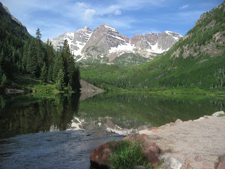
We drove up to the Maroon Bells today, and there was no 4 wheeling necessary. It is $10 a car for a 5 day pass. Secret is that you have to be in the gate by 9 am or else you will have to take the bus. We drove through and paid our $10 and drove to the end of the road and found a parking spot. There were already 10 or so cars in the lot. I think these were either people who backpacked camped the night or one of the several photographers who lug around their cameras/ mango lenses and heavy tripods. Maroon lake and Crater Lake can make any picture taker look like a professional photographer, with or without the mango lenses!
 |
| Maroon Lake |
We snapped about 20 or so pictures and then headed on down the trail for Crater Lake ; where we snapped a bunch more. Then off to the hiking trail to see what this side of the Maroon Bells looks likes. The Ranger at Aspen
Along the way out to the first major river fording, we had to cross several side run off streams that were coming down the side of the Bells. Most crossings were rather straight forward and simple to negotiate. We came to one that we were able to watch a man and lady balance across a section of pine trees that were laying across the rushing water then step into a large willow clump just on the other side, then wiggle their way through the willow and ta da, they were standing on the other side! We are next. As Kathi approaches the log all is well. The next thing I know Kathi’s Olympic début for Balance Beam has gone seriously awry. She had the dismount skill at the beginning of the balance beam routine and not at the end of the balance beam routine! When Kathi stepped on the log to the right it moved and dumped her right foot into the rushing stream, then she lost her balance totally and the left foot went in also. She fell backwards and landed on her butt. Fortunately the butt landing was not into the water, but rather up on the bank. She was ok, but no amount of water proofing can keep the water from getting into your boots when you go in up to your knees!
 |
| Kathi after her 'dip in the water' |
 |
| Kathi on her second try walks across and into the large willow. |
Before we left for vacation I had purchased from REI these cute little quick dry towels that fold up really tiny. You just toss them into some pocket in your backpack and use them if you get “wet”. Hah, now is the perfect time to test those quick dry towels out! We were able to use the towels to wick the water out of the inside for Kathi’s boots. Then like all good hikers we pulled dry socks out of the pack to get Kathi up and hiking again with dry feet!
We still had to cross that little spot, but were a bit more careful to put the dismount at the end of the balance beam routineJ
 |
| The water is about 15 feet across here and about 4 to five feet deep. Way too fast and deep to ford. |
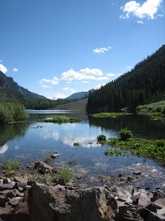
We found the hike up to the first river fording to be very rocky. There were certainly lots of things to look at, but not the jaw dropping flower show that we saw from the other side last year. Everything seems to be about a month behind schedule with the flowers and snow melting. We reached the 3.6 mile river ford after 3 hours of hiking. We found the water high and fast and we found the snow bridges to be less than ideal. When you are watching water enter the upper end of a snow bridge and rush out the bottom end of the bridge you really wonder how deep is that snow yet??? Will it hold if we walk across it? If we make it across, will it still hold us in an hour or two when we want to get back? Crossing does not seem to be a “good idea”. So we sit down and pull out our topo and study it to find something else to hike in this valley. We set our sights on Buckskin Pass. Crater Lake . Before we leave we stand on the rock pile and play a new game called snow bridge rock hurling. We tossed big ole rocks out onto the edge of the snow bridge to see how easily the snow bridge would break and fall down into the rushing water. This new game was rather fun to see how far you could hurl a large rock and see if you could get it close enough to the edge of the snow bridge to bust it. Perhaps this is just a game that seems fun when you are standing and wondering if that snow bridge would hold your weight, and decide not to try and find out J
 |
| Crater Lake |
The hike back to Crater Lake is down in elevation and then we will have to go up to Buckskin Pass. Buckskin Pass and Willow Pass Buckskin Pass
We turn for the hike down and begin to create a list of hikes that we would like to do in this area if and more like when we come back. We wish that we would be staying longer in this area and not traveling to Estes. But the rooms are already paid for so we best just come back her another day.
The whole day was filled with sun shine and perfect temps. What a great day! Except for that part were Kathi took a dip…
 |
| Looking up at Buckskin Pass with it's Snow Cornice. Also watching people come down from the pass. |


No comments:
Post a Comment