RMNP 16 Notch Top Mt. Bear Lake to Fern Lake

RMNP 16 Notch Top Mt. Bear Lake to Fern Lake

Sunday, July 31, 2016

Lions Lake 1, Out of the Wild Basin Trailhead

Today we are up really early so we can travel by car 45 minutes down to Indian Peaks Wilderness at the Brainard Lake trailhead.  Indian Peaks is the area of protected land just south of RMNP and has more hiking, it is somewhat less crowded, but a tad less trail maintained.  As in even more rocky trails.  As we were driving to the trailhead the dark heavy clouds were sock’ing in.   Just as we got to the gate check in it started to sprinkle/rain. We got out of the car and went to talk with the person at the pay gate.  These people are usually pretty helpful. This guy was as little help as one could possibly imagine. He didn't know if the rain was going to blow over or even if something that “looked” like the current situation usually blew over… He did know he had his toast in the toaster in the office and it had just popped up out of the toaster.  It was quite clear he wanted to get back to the toast and not deal with two women inquiring about weather conditions.   So judging from what we could not see due to the heavey clouds, how low the clouds are hanging, and the current precipitation falling from the clouds we decided to just grab a trail map and turn around to head back towards Rocky Mountain National Park.   As we were driving back we're looking at the area map of RMNP and trying to decide on where to go to hike and not get rained on. We decided to just hike at the Wild Basin which was on our way back.  We had on our hiking list a a hike out to Lions Lake. Lions Lake is a pretty big day trip at 7.1 miles to the lake one way.

The road back to the trailhead is a single-lane gravel road with an occasional little extra footage where one could pull to the side while another car could pass you. We are hoping that when leaving later today that we wouldn't have to try to pass anybody!  We arrived at the trailhead and there were so maybe 7 other cars there and people were putting on their rain gear as it was sprinkling a little bit.   it was kind of chilly so we took along a heavier Dri-Fit long sleeve as well.   We put on our backpacks and hit the road hoping that we would have a dry day.

The trip to Lions Lake 1 is right along the river and you get this wonderful water display for the first part of the hike.  First at Copeland Falls , 1.8 miles further up the road you get to see Calypso Cascades, and then at the 2.7 mile mark you get to see the Ouzel Falls.  This trail is just a really wonderful waterfall trail.  As a little side note, we had a chance to walk across the new Ouzel Falls bridge. I'll include a picture of it. The story as told by our friendly local Ranger volunteer is that in 2013 RMNP trail workers had just finished installing a brand new bridge.  A real beauty made from all trees found near the sight.  4 Weeks later, the Rocky Mountain Park area had major rain storm with lots of flooding.  That brand new 4 week old bridge was washed down the river (many other bridges in that area also washed away). The bridge had to be rebuilt. The new replacement bridge is a very good looking bridge made from all from trees found locally.  

A bit further up the trail from the new bridge is a split in the trail, Thunder Lake and Lions lake.  We are heading up to Lions Lake 1. Thunder Lake does not have much of an elevation gain after this point.  (Special note: Thunder Lake would be a really great second day hike if you ever come to RMNP to do some hiking. )  Lions lake does have a lot of elevation gain after this point.  The overall the trail gains +2859 feet most of which comes during the last 2.2 miles.

Arrived at Lions Lake to find a lake in a beautiful basin. Rising up on the backside of Lions lake is a waterfall. From where we are standing it is easy to see where  Lions lake II and above that lake is lions lake III are located.  If we had a little more time and a little more energy I think we possibly would have gone to Lions Lake II.   Clearly, with the lake being 7.1 miles one way,  it is difficult to think that adding further milage is a good idea.    We took some pictures and sat down for some lunch.  While eating lunch we noticed some deep dark clouds coming our way so we packed up and set off to get moving back down the trail.  We had a long walk back.  Within about 15 minutes the dark clouds had blown over and the partly sunny skies returned.

Today’s totals are 14.37 miles walked in 7 hours and 43 minutes.  We stopped a lot to take pictures on the way out to Lions lake.  On the way back we just looked and tried to keep moving, 7.1 is a long way back.  Again this trail has lots of water to look at for half of the trip.
After the long hiking day we drove back to the cabin to find a little neighborly gathering happening.  Our cabin is located in a small group of four cabins all owned by two business partners.  Kim, one of the owners, was visiting with their “Artist in Residence” cabin dwellers, Lou.  Lou lives in the cabin by us.  He has a very old dog named Harley and a spry young cat named Jack. Jack is a cool cat, and has spent much of his time over by our cabin doing what cool cats do.  Rolling around and looking like a loving cute and friendly cat! In talking, with Lou and Kim we find that Lou has done all sorts of work in the cabins making each cabin unique and special.  I will include a few pieces that he made.  Lou has in our cabin used beetle kill pine wood to put the silhouette of the front range above every door jam.   Also the kitchen back splash and towel holders are pretty darn cool too.  Great talent.


New replacement bridge

Ouzel Falls


falls

Just a few flowers along the way


Before you arrive at the lake there are a few ponds that add to the beauty


Lions lake II and III up above the the waterfalls

Great sights.

Recording in my note book the time of our hike.  Dark clouds coming.

Pano Lion's Lake I

Bathroom towel holder.  Birch branch towel holders with stained glass made to look like birch trees dropping their leaves in the fall.

Close up of the towel rack

Backsplash behind the kitchen sink


Saturday, July 30, 2016

Loch Lake, Timberline Falls, Lake of Glass, Sky Pond

The Loch, Timberline Falls, Glass Lake and Sky Pond

Today we started our day at 5:30.  We need to get hiking earlier today as it is now monsoon season and storms are forecasted  around 2 ish.  It really is interesting that every time we come to Colorado so does the monsoon season.  Colorado does need the rain, but seriously how does this happen.

We parked at Bear Lake and took the shuttle down to Glacier Gorge trailhead.  We made really great time today because we beat all of the crowds.  We quickly zipped up and past Alberta Falls.  The overlook to this falls is a real people jam.  I think the falls is about as far as the vast majority of hikers care to venture up the trail.  It is a 200 foot elevation gain and 1.7 mile round trip. ( It is fine with me that the majority of hikers stop here.) This morning there were only two other people tucked into special spots with their cameras all tripoded up and waiting for the “ just right” sunlight moment.  We proceed up to Loch lake.  The mosquitoes on this hike were really bad.  Had to stop and apply lots of bug juice.  The bug juice that we are carrying is great stuff, but the spray bottle leaves much to be desired.  Not sure why the spray bottle design was chosen?  The spray applicator head does a better job of leaking than that of retaining the product to be able to spray it on.   Perhaps the company put all of their dollars into developing a quality spray and did not worry about the applicator.  We have the leaky bottle quadruple bagged to catch any leakage and to protect our gear and lunch from being contaminated.   We end up pouring the leaked bug juice back into the bottle from three of the four zip locks. That is a BAD sprayer head!

When we were last up to Loch Lake the RMNP trail crew was working on renovating the trail to Timberline Falls.  We are sort of interested in how it looks. We find the renovated trail all laid out with timbers, gravel, and large stepping stone rocks, a huge boulder staircases all laid in just the right spots. It made for a really nice pathway up to Timberline Falls. Once you get to the falls that's where all the really nice laid out pathway ends. The Park does not want to make it too convenient!  A little risk should be involved when hiking!  

We got up to the falls took some really great pictures. Kathi pulled out her GoPro and captured me growing up through the falls followed behind by her “in person view “ of her climb. From the base of the waterfall the trail continues up a chute to the right of the falls.  This is a fair scramble that climbs roughly 100 feet, and requires hand holds, inseams longer than 30 “ and the use of all four limbs while ascending and descending.  The first 30 feet or so are the most difficult, but beyond that it is a relatively easy scramble.  Just to complicate things a little bit more, portions of the climb may have water flowing down the route. :) This fact may increase the possibility for boot siip’age...This is a scramble, so I watched several people coming down and a couple people going up to best gage what path looked best. Really it's a matter of trying to decide what is the best place to put your foot and what is the best place to put your hand without taking a plunge Into the falls. As usual the scrambling here is meant for somebody who is taller than 5’ 6”.  I'm sure my video is worth a laugh or two as I had to scramble up there and crawl up in my knees a couple times because the step was just too big, oh well I got to the top.

When you get up to the top of the falls you walk straight ahead and right in front of you is a beautiful lake called Lake of Glass. We took some pictures looking out over the lake as well as some pictures looking back over the much lower vista of Loch Lake. From here we moved on around the lake.  After a bit more of climbing we arrive at another lake called Sky Pond. All tucked back into a beautiful deep grey cirque. Up here we shot some more pictures and did some scrambling across some big rocks and shot some more video. We sat down and had a snack. Our goal was to get the back to town early so that we could do some shopping and then go to the grocery store.  You might laugh at this goal, but since town is soooo very busy it will take some nifty traffic dodging to limit our time caught in the Estes Park traffic jam.  Also the Safeway (grocery store) in town is the busiest Safeway in all of Colorado.  The store is teaming with vacationing people who are trying to buy groceries as well as a staff who are busy trying to keep the shelves stocked. CRAZY PLACE!!! Plan on no less than an hour and a half for the grocery experience even if all you need is a pizza crust and some ice cream!

Today on our trip back to the trailhead we ran into another volunteer Ranger.   No, no, no, it wasn't our happy volunteer Ranger who knew a lot about ground squirrels, it was a ranger who was local and was able to provide us a lot of information about some questions that we had. He informed us about why all the trees were lying all over the trail on our way to Black Lake yesterday. He told us it was because many of the downed trees had been damaged by the pine beetle and during a very high straight-line windstorm the trees easily blew over. Estes Park has some very very strong winds during fall and winter,  often reaching 50 to 80 miles an hour. He thought it took about 4 months of work to chainsaw a path through all of the downed trees to open the trail back up to Black Lake.

We also talked about how much damage we saw with the pine beetle since our last trip to the park five year ago. At that time most of the beetle kill was on the west side of the park.  Now, it is pretty much everywhere. He told us about why we saw all these huge wood teepees  in parts of the park.   (I use the term wood teepees as it is a lot of wood all standing together in a teepee formation.)  Lots and Lots of wood teepees! In high use areas the Park is going in and cutting down the trees that are damaged by the pine beetle so the trees don’t fall on someone.  Then the Park is stacking them into large teepees so that  on a very cold winter day when there's lots of snow, and no wind the teepees will be torched. There is so much excess wood that the park just needs to get rid of the downed fuel sources.  

Our Ranger also talked about the floods of 2013 and some of the damage from that event.  Stay tuned for further information on that!!!

9.9 miles today
6 hours 36 mins.

Pano Lock Lake

Pano Sky Pond

Large Gulch on way up to Lock lake

Lock Lake inlet, Andrews Glacier upper right corner


Andrews Glacier has melted it corniced top since we have been here 5 years ago.  Looks tiny now.


Basin back by Timberline Falls

Timberline Falls

Hmm where should I go?

Looking back at Loch Lake

Kathi climbing up

It is steep

Looking back to Lake of Glass from Sky Pond

Sky Pond

Nice path

Looking back over Lake of Glass from Sky Pond


This is a favorite picture with all of the people standing on the large boulder at the outlet of Lake of Glass.  

Friday, July 29, 2016

7/17/16 RMNP Black lake to Frozen Lake

Okay time to turn on some music and dig up your soundtrack to the of the movie Frozen. Today we're going to hike up past Black Lake and get to the top of the Glacier George Basin. Then we are going to see if we can find the lake called Frozen lake. This lake is tucked up to the right of a large mountain called Spearhead. To get there and back you are going to have a +2,338' net elevation gain (+3,011' total roundtrip elevation gain) and 13.5 miles on your boots by the time you get back to the car.  Remember to start early because it's going to be a long day.


We started hiking at 9:30 from Glacier Gorge. Silly us, we had tried to drive up and find a parking spot at the Glacier Gorge parking lot, but it was already full. (Where have all of these people come from?) Eleven minutes later we were back down at the park and ride lot. Lucky for us we scored a spot to park the car in the second parking spot which was nice and close to the bus shuttle. Once we arrived at Glacier Gorge trailhead we get going right away. On our way we bumped into a volunteer Ranger that we stopped and asked some questions to see if she had ever hiked out to Shelf Lake, which is another off trail location we are thinking about hiking to. She didn't really know what we were talking about, but she knew an awful lot about ground squirrels. This is not really very helpful information for us at the time. We thanked her for her time and hiked on.  While we are taking some pictures of Alberta Falls, the volunteer ranger caught up with us again and told us that she had talked to another gentleman about Shelf lake. He had been up to it a couple weeks ago. She pointed him out to us and we went up and talked with him to gain any knowledge he might like to share about the trail. He was very helpful and did some drawing on our map to try to tell us where we should be looking to find the the un-maintained trail.  He talked about a few pink ribbons hanging from the trees to sort of lead the way and then we would have to do some scrambling over some branches and such.  We thanked him for his time and got back to heading on our way.  Today our destination is to head out to Black Lake, head up the inlet stream bed to the upper basin, then we hope to find Frozen Lake.  There is no trail to Frozen lake, just some general points to head towards.  You need to hike up towards Spearhead Mountain and then veer to the right side of it to find Frozen Lake.  Kids at school would never get away with writing so little supporting details.  


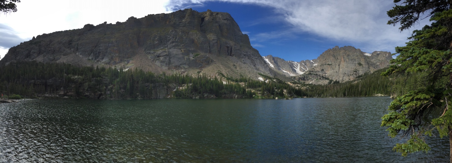
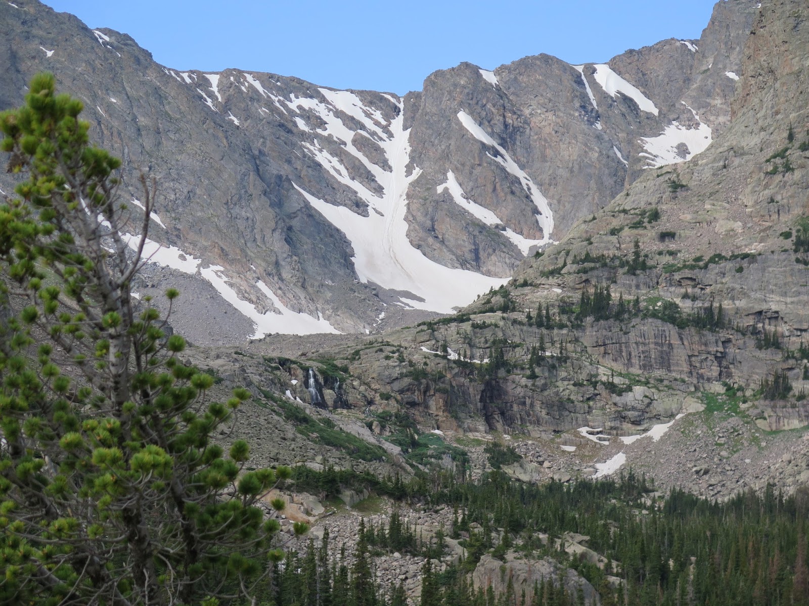
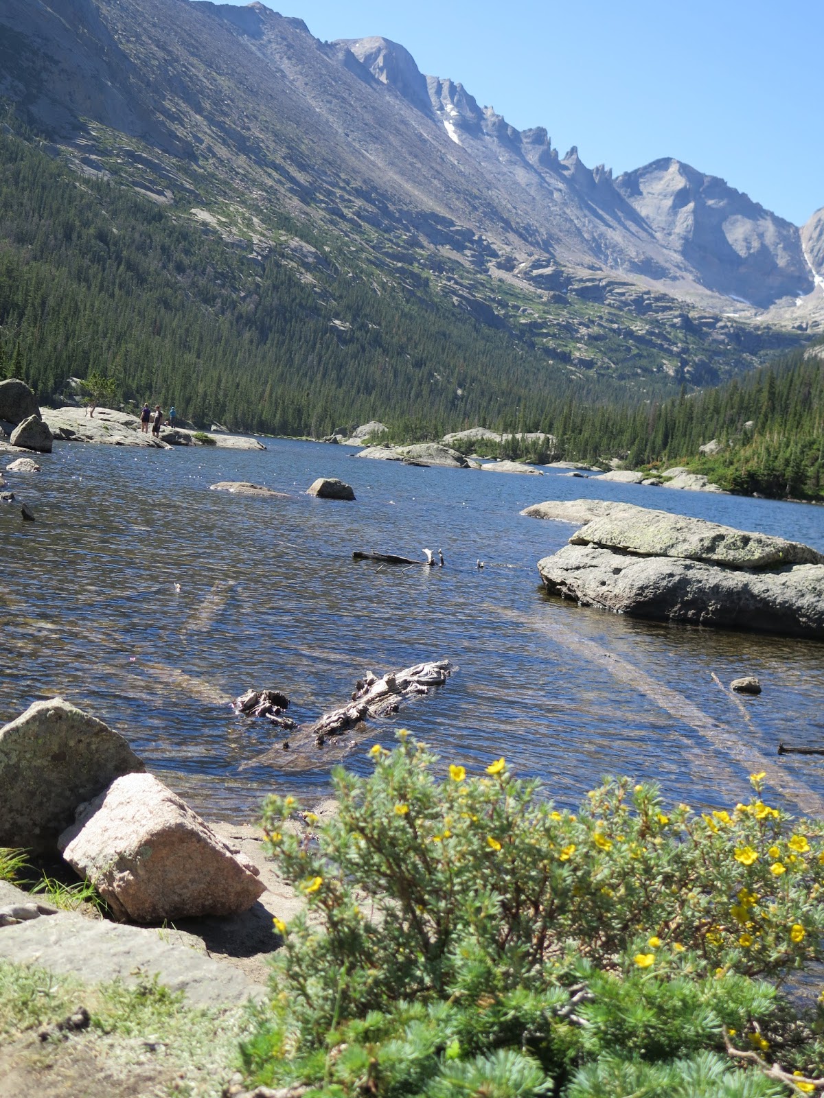
While we are hiking out to Black Lake, we think that we can look for the turn off to Shelf Lake. Thinking of course that a trip to Shelf Lake on a different day would be a nice adventure. We were unsuccessful in locating the trail to Shelf lake on our way out. We tried very hard to try to find that trail but failed to locate it.  We were looking for a sort of game trial headed off to our right after we entered a meadow area about a mile past Jewel Lake, but we never found it.   Hundreds of trees had been blown over, along this area and the trees were cut and moved off of the trail.  Apparently RMNP has very high winds and straight line wind sheers that come through in the winter and it took out all of the trees in this area.  Good thing for us some lucky trail maintenance person was assigned to cut and drag off all of the downed trees.  We did make it back to Black lake without too much trouble. It's a gorgeous gorgeous lake tucked back into what looks like a cirque, but really you have to head back up and around the lake to find the real secret gem of the hike. As you head up the inlet river ravine you arrive at the upper glacier basin.  Wow, Wow, Wow! Big huge and amazing.  


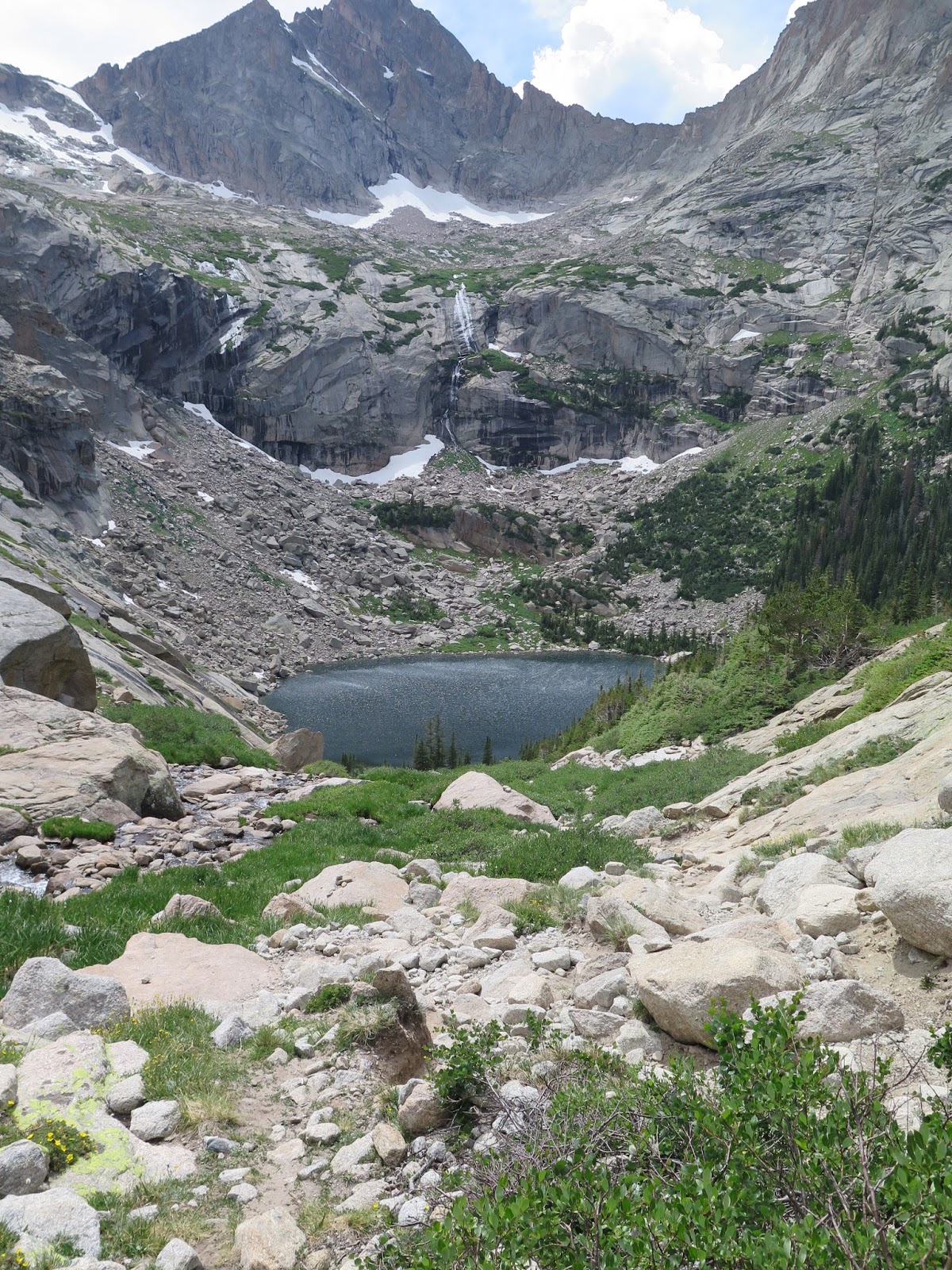
We made it to the top and met a few people along the way and asked them if they had been to Frozen Lake.  We found one person who pulled out her phone and dialed up a couple of pictures we should look at to use as reference points.  We thanked her and continued up to the end of the trail.  Yes,Yes, Yes, the trail does in fact end. From here we got out the directions from Pro trails and read those and put some GPS coordinates into our GPS and headed out towards Spearhead. At this point we are less than a mile away from Frozen lake. The problem in getting there was that we had to climb up, around, over and through small krumholtz, long slabs of granite, navigate a waterfall, cross surprise ravines and just keep moving towards the right of Spearhead while looking at the GPS for directional guidance. During this whole time we could hear people talking, but could not see them. This little "less than a mile" took us about an hour and a half as it was pretty labor intensive but at last we found Frozen lake.  A really good Gutsy Girl Hike!  (OK, Im reading this book  called Gutsy Girl, and it was a very gustsy girl hike today!)   It was beautiful. We hopped around there for a little bit, took some pictures, and then sat down to have some lunch while watching two peole mountain climb way high up on Spearhead mountain.   We took a really great photo of one person standing between a cut slab and the mountain. At 1:45 in the afternoon we decided we better get heading down. For the return trip back across the large basin we used our GPS and followed the "backtrack" option.    We basically followed our every foot step back across the very large Basin.  The whole return trip back to the "end of the trail" or in this case the "beginning of the trail" was all within 20 feet or less of what we came in on. As we got back to where the trail started up again we were greeted by a herd of female and baby elk that were sitting down in the snow or in the shade trying to cool themselves.   They were very close to the trail and it was very tight in there so we got some nice pictures of the elk.

The hike back is always long. Going down hill is never a favorite of ours as it is hard on the feet and knees.  We made pretty good time down to Black Lake where we sat down for a quick snack and a little work on a blister.  Then we tightened up the boots for the remaining 4.5 mile trip back down to the bus.  


On the way down we located the trail to Shelf Lake and walked out to the point where you have to cross the river.  It was not really by anything that I would call a meadow, like the guy told us.  We noticed the trail had lots of downed trees laying all over the place.  Since no guy with a chainsaw would have cleared the trail, we decide while standing there we really didn’t need to do that Gutsy Girl hike.

For the day it was a very succesful gusty girl hiking adventure using the GPS to find Frozen lake and then to find our way back across the upper basin back to the inlet stream for Black lake.  A very long day of 13.5 miles of hiking. Long day! Nine hours!!!


Black Lake

Black Lake

Black Lake

Female Elk herd with calves in tight ravine


Upper Glacier George


Frozen Lake is somewhere up there to the right of the Spearhead

GPS found it!


Learn how to use your GPS...it is very convenient!


Lake has floating Ice Bergs in mid July


Looking up at the back side of Longs

We think the trough for longs is way at the top of this picture??

Hearing voices???

Do you see them?

This is big time Gutsy Girl!!!  Not for me!

Elk laying down and letting us pass by


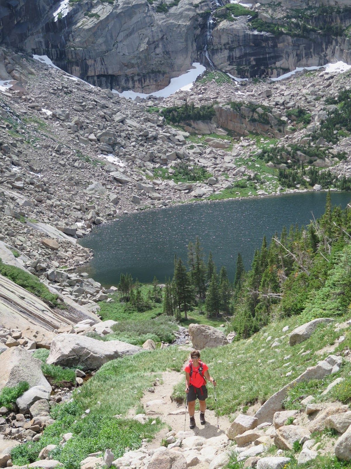
About half way down the gorge Black lake looks tiny.


Jewel Lake

Part of Alberta Falls

Rainbow falls comes out of Black Lake

Pano of Upper Glacier Gorge

Pano of how are we going to find our way back??? Use Backtrack on GPS!